
NS in Eastern Appalachia
Saint Paul, Virginia - Frisco, Tennessee

Introduction
This is a segment of the over-all Frograil NS Appalachian Tour. Information on the overall tour is here. This segment is complete, and traverses some of the grandest mountain railroad territory in the east. Legendary names like the Interstate, Clinchfield, Southern, L&N and N&W are encountered, and if you like mountain railroading, you'll love this tour. Much additional information about this segment of the over-all tour is found in the Supplemental and Back-up Data information.
Contents And Navigation

Contributors
NS_CSX_Appalachia@yahoogroups.com . This e-mail group's members have been fantastic in their willingness to correct, supplement, and improve on the quality of the tour information. Those who provided info include Ron Flanary.
Tony Hill. Webmaster -- the guy who makes Frograil go. All text between Saint Paul and Bulls Gap is Tony's, unless otherwise specifically stated. Any first person singular pronoun used in these tours refers to Tony, unless otherwise specifically stated.
Help
If you'd like to contribute to this or any other Frograil tour, simply e-mail me here , and let me know what you're interested in. We'll work together -- you supply the data, and I'll take care of the HTML stuff. Frograil can only be as good as its contributions, so keep 'em coming. Over 1,100 folks a day visit Frograil, so your material will not just be moldering away -- it will be used by railfans.
Supplemental And Back-Up Data
Abbreviations
Life Support
Mapwork
Photographic Considerations
The Railroad -- Geography
The Railroad -- Traffic
The Railroad -- Geography. Saint Paul to Big Stone Gap is mountains. Big, sprawling mountains, and these form the underlying basis for anything related to transportation, business, and daily life in this part of the country. Nothing is flat, and nothing is easy for truckers and railroaders. To see a loaded coal train out of Appalachia tooling along at 45 miles per hour doesn't sound like much -- but only if you've never been there. This is impressive 21st Century Railroading, and it's exciting. The mountains are relentless -- they never stop anywhere in this segment, until you finally get south of Big Stone Gap. There are still lots of mountains south of BSG, they just get spread out more. And then, when you think you're finally out of the mountains, the biggest, meanest, monolith of them all -- Clinch Mountain -- forms an immense wall across fully 2 pages of the DeLorme Atlas & Gazetteer. This is great mountain railroading, and it's great fun to see.
The Railroad --Traffic. Frisco - Appalachia - Saint Paul on the Norfolk Southern form a western arc to the CSX Frisco - Dungannon - Saint Pauleastern arc. Both railroads' trains run on each others' tracks, and you can see NS trains on CSX tracks, and CSX helpers gliding downhill on NS tracks. Anything goes, anywhere. Add in an almost incomprehensible mix of foreign power, and you have a more than mildly interesting power mix. The trains are coal trains -- loaded and empty, and that's it. You won't see intermodal or even manifest, as this part of the country's tracks play host to King Coal only.
Photographic Considerations: As I've done in several Other Tours, I've attempted to rate the photo fields for all 4 quadrants of many crossings detailed in the tour. The following format is used: NE2, SE1, SW4, NW4, where you go clockwise around the quadrants from northeast to northwest, and numerical ratings, from 1 to 4, with a 1 being excellent, and a 4 being non-existent, are assigned. Note that I'm rating only photo field availability, not the photogenic qualities of the site. I'm a picture taker, not a photographer, and you guys who are good photographers will have to make your own determinations.
Also, note that the photo ratings in the mountain are different from those in the coastal plain. The sites in the latter tend to be wide open. There are few "wide open" anythings in the mountain, so a good photo rating in them would be a much lower rating in the plain.
Life Support. Even though this is mostly a very rural tour, much of it is close to US-58A or US-23. Even though you're out in the semi-wilderness for most of the tour, the next town is only a few miles away. Food and gas are certainly plentiful, and motels are not all that rare. Hospitals are in Big Stone Gap and Norton. For fine dining, go to Bonterra's Restaurant in Wise/Norton.
Abbreviations. Some phrases are used repeatedly in this tour, so I've developed some standard Frograil abbreviations:
AG. An at-grade crossing.
NAG. A not-at-grade crossing. Unless I mention otherwise, these are usually not worth the time and trouble to drive to.
NARL. Not a railfan location. This is because of any number of reasons, such as lousy photo ops, dangerous, no shoulder on a NAG bridge, etc. As a general rule of thumb, it is wise to avoid NARL's.
NFOG. Not found on the ground. Often, very minor roads depicted on maps of rural areas do not exist on the ground, turn out to be private driveways, or have become overgrown in forests. I lump these together in the NFOG category.
Mapwork: Much of the tour is not easy if you have no detailed map for back country roads. I definitely recommend you get a DeLorme Atlas & Gazetteer, study it before your trip, and copy pertinent pages for your field work. You can find information here about Railfan Maps that are available.
WEBMASTER'S NOTE: I do not recommend, or even condone, walking along the tracks, as this means trespassing or exposing yourself to danger. You will have to be creative, in some instances, to avoid trespassing while getting to the detailed locations included herein, but you will either have to be creative or not visit those sites. At no point in this tour guide, or any other tour which is part of Frograil, is it recommended that you trespass or expose yourself to danger. If you are a fool and have a leg cut off (or worse), don't come crying to me: You have been warned. Trains are big, powerful, and often surprisingly quiet. Don't end up being a statistic.


Railfan sites:
The Tour -- Saint Paul, VA - Frisco, TN
Saint Paul -- Boody East. Technically, when the entire NS Appalachia Tour is completed, the Bluefield - Saint Paul segment will end at Saint Paul. However, as a temporary measure, I've covered two locations just to the east of the railroad point "Saint Paul", and we'll start with the easternmost of the two. Assuming you're starting the tour here, take US-58Alternate (hereinafter written as "US-58A", as we will refer to it constantly) from Abingdon to the town of Saint Paul, a distance of about 30 miles. Abingdon is on I-81, the interstate you love to leave.
US-58A, which is Bull Run Road in the area, will cross the Clinch River, and you'll take the well-marked turn right onto VA-63/Wise Street, and travel east, all the way thru the small town. CSX (ex-Clinchfield) and NS (ex-Norfolk & Western), will have come in from the west, and will be far below you on your right. VA-63 will take a very pronounced 90° turn from east to north, and you should look for VA-628 to the right. Take it, and go down the hill, under a viaduct carrying the Clinchfield from Haysi and the north into Saint Paul (this underpass is only 9'7", so you guys with big camper rigs might want to pass on this location.). Continue on and cross the eastern leg of the wye, carrying NS trains from Bluefield up to join the Clinchfield (a lightly-used track), and park immediately past the latter tracks to the north. This parking area is really a driveway up to an inactive coal facility.
[NOTE WELL: On this tour thru the mountainous region between Saint Paul and Frisco, you'll be traveling on many small country roads. Most look like they might carry 5-6 cars a day. Do not be fooled by such looks. Virtually all of these roads are busy, and the locals know them like the back of their hands -- and drive much faster on them than would strangers like you and I. Be very careful parking, walking along, and taking photographs from these roads. They can be very dangerous places for the railfan tourist, if you are not alert at all times.]
The trains from Bluefield and the north come in on the leg that comes from the south here (the mountainous region plays havoc with directions!), and you've got a good chance of seeing a train idling here awaiting a fresh crew. There are several NS tracks, but the photo ratings aren't really that good: NE4, SE3, SW1 (walk across the tracks on the public highway crossing and shoot to the southeast), NW4.
Back to the Site Listing Back to the top
Saint Paul -- Boody Wye. Once you cross the tracks of the west leg of the wye, you can approach the viaduct carrying the CSX tracks from the southwest to the northeast. The view rates about a 2 for photo fields, but the views to the south along the NS south leg of the wye are very much obscured. I think this is a safer place than the previous location, and the trains just seem more impressive, even if the pix are next to worthless. Even though this is just a few yards from the previous location, the "look and feel" of the place is completely different.
Back to the Site Listing Back to the top
Saint Paul. This is quite a place, but for the uninitiated, it's hard to tell. Photos are poor here, and your legal range of motion is about 4 square feet. However, if you're into eastern mountain railroading, you will want to know this location. At the risk of being redundant, here is what happens: The Clinchfield (CSX) has come up from the southwest, having taken advantage of its tunnel thru Clinch Mountain, and via the relatively easy grade of the Clinch River. The NS (Southern/ Interstate/ N&W) has taken a loop around Clinch Mountain, thru Big Stone Gap and Appalachia, thru Norton, and into Saint Paul. Both of these lines come together about 30 yards to your left here, run together on single track for maybe 15 yards, separate, and CSX goes to the north, and NS goes more northeasterly. ALL CSX/NS coal traffic for a whole lot of square miles filters thru this narrow neck of trackage.
From your parking spot back at Boody, go back up VA-628 to VA-63, take a left, and drive back into beautiful downtown Saint Paul. At the traffic light, take a left onto 4th Avenue, and go under the tracks. Take a left onto Riverside Drive, which will lead to a municipal park. Drive all the way to the end of Riverside, and you'll see the metal stairway leading up to the level of the tracks. Walk up the steps and STOP; to venture beyond the steps is to trespass. You can get so-so photos from the steps, but the real reason to be here is just to enjoy the coming together of the Appalachian traffic in this one location. This is a mega cool spot.
Back to the Site Listing Back to the top
Saint Paul -- US-58A. Retrace your drive back to the traffic light on VA-63, turn left, and then turn right to head further west via US-58A. As you leave the Saint Paul area, you'll see NS come in on an interesting embankment from left to right. Pull off and park. If you're a real photographer, and not just a picture taker like me, you can get some dazzling shots of trains along the embankment, but light, shadow, and subject take a lot of patience and know-how. I think this left-to-right panorama has some real potential. Of course, at other times of the day, it's the right-to-left panorama that has the potential!
Back to the Site Listing Back to the top
Banner -- Turnstone Road. The next 2 locations are very high, curving trestles up, up, up over the valleys they traverse. They are both very close together, but each offers different lighting, clutter, and subject issues. As you climb out of the Saint Paul area, you will note on your map work that there is a junction well south of US-58A, via Russell Creek and Bill Dean Roads, respectively. While you can get close to the junction, everything is treed in, the tracks of the old branch to Caledonia are long gone, and the crossing at Bill Dean is NAG/NARL. Keep going west on US-58A. Ultimately, you'll pass Greene Road on your left. Watch for Turnstone Road on the right.
Turnstone Road is a dirt track leading to several homes in a true hollow. The trestle is ultra far overhead, and pix are definitely a mid-morning to late afternoon winter shot. Forget it when leaves are on the trees. Parking is a problem. Park off US-58A and hoof it in. Do not linger.
Back to the Site Listing Back to the top
Banner -- Lawson Hollow Road. No more than 1/4 mile west of Turnstone Road, watch for Lawson Hollow Road, which is actually on the map! There is a much better view of the trestle over this valley, with much less clutter. However, the alignment is different, so it may or may not offer a better shot than that from Turnstone Road. It would probably be better earlier in the morning, but not as late in the afternoon. You true photographers will have to work that out yourselves. Both are way, way up, and way, way cool.
Back to the Site Listing Back to the top
Banner -- Bull Run Road. Beyond Lawson Hollow Road, US-58A/Bull Run Road, will become a limited access highway towards Norton. Avoid that by taking the exit to the right, to continue as Bull Run Road into Banner. The tracks are just south of the road, and are readily accessible. You can shoot an excellent field to the south, tapering off to an OK field to the southeast. If you care to hike up the opposite hill, you'll get good shots east and west. Mile point marker CV 453 is at this location.
Back to the Site Listing Back to the top
Banner -- VA-158 Bridge. As you roll into Banner proper, the tracks are just on your left, but there is a lot of clutter that precludes any photos. Not found on MapQuest is what appears to be a fairly new bridge from the old Bull Run Road/US-58A, over the tracks, to the new US-58A By-Pass. As is frequently the case, the State of Virginia re-labels an ex-US highway by placing a "1" in front of the old number. Hence the old US-58A has now become VA-158 at this bridge. The tracks under the overpass are pretty open, at NE4, SE3, SW1, NW2. Obviously, morning trains from the west are prime targets here. The higher the sun, the better, as this is a fairly serious cut.
Back to the Site Listing Back to the top
Coeburn -- Skateland. Continuing west on VA-158/Bull Run Road, you'll go along a fairly level, easy piece of countryside along the railroad. There are lots of trees and brush obscuring most of the railroad, however. If you are alert, you'll see a vestigial sign for "Skateland" (this is a small sign -- maybe 2'x3') off to the left. The building that was Skateland, as well as the road over to it are both long gone. However, the railroad is still there, and the views from the Bull Run Road area still vary from OK to excellent.
From the area of the Skateland sign, there are intermediate signals about 500' to the west. You'll see a defect detector just to your right. The photo fields are 3 to the east, and 2 to the west, but 1's in both directions across the tracks. You'll want to move around here and do some planning, because good photos can definitely be had, but you need to plan ahead.
Back to the Site Listing Back to the top
Coeburn -- Dickerson Avenue. As you're coming into Coeburn proper on Bull Run Road/VA-158, watch for a very minor road, Dickerson Avenue, on your left. Take it, and bend 90° to the west. Park and walk to a location behind the house to the west. You do not want to walk on the private property of the latter, but you can shoot across the property from the road, and the pictures might be pretty interesting. There are no shots from south of the tracks, and shots back to the east are poor. MP CV 455 is here.
Back to the Site Listing Back to the top
Coeburn -- Quillen Avenue. Keep going around the loop formed by Dickerson Avenue, and you'll pop out back at VA-158, which is now called Front Street. Take a left; ignore VA-72, which is NAG, and I consider it to be NARL. At Quillen Avenue, take a left, go less than one block, and take a right into the municipal parking lot. Park between the stripes at the northeast quad of the lot. This is a great place to railfan if you have a family. There is a park to the east of Quillen, and it offers a picnic shelter, picnic tables, play ground, and caboose NW 24230. The quad of the Quillen Avenue crossing is not a photo location, but it's a great family location.
From the parking lot itself, the photo fields are excellent, but you are firing into the sun. Probably the best photo field is from the southeast, which offers excellent shots to the east for early and mid afternoon westbounds. There is no shot from the southwest.
Back to the Site Listing Back to the top
Coeburn. A short distance west via Front Street/VA-158 will bring you to a crossing. This track is the Big Toms Creek Branch going off to the north. Contrary to many of the Appalachian coal branches, this one is alive and well, and the rails are well polished. You can see the junction, "Coeburn" by taking a left before the tracks, and parking in the convenience store parking area. Shots of the branch line crossing VA-158 are wide open, with 1's in all 4 quadrants, but there are no shots of the actual junction or main line thru here without trespassing. This MP 455.6.
Back to the Site Listing Back to the top
Tacoma -- Main. Continue west on Front Street, and look for Old Norton Coeburn Road on your left. Take it, go under the US-58A Bypass, and you're almost immediately back in the country. The tracks are very close on your left, but viewing and photo fields are limited because of trees and clutter. Look for a hard left, Riverview Road, and take it. To the west is the beginning of a short passing siding, and a 3rd siding track. This point is Tacoma Main. To the south, out of sight, are the remains of the Interstate Railroad. Photo ops at the crossing are NE2, SE4, SW2, NW3.
Back to the Site Listing Back to the top
Tacoma -- Remote. As you head further west on Old Norton Coeburn Road, you'll see the tracks below you. The sidings end in a place that is inaccessible, and well below you. Look for the Lonesome Pine Racetrack (LPRT) on your left, and take the road into it, do a U-turn and leave the LPRT property, parking on Old Norton Coeburn Road facing east. As mentioned, there is now one main track coming from the east. Immediately to the west of the crossing is the beginning of a second main track, which is the connection to the remnants of the Interstate Railroad. Between Tacoma Remote and Norton, NS operates the ex-N&W and ex-Interstate as a 2 main track railroad. You'll see loads and empties on either line in either direction at any time. We will continue to follow the ex-N&W into Norton.
Back to the Site Listing Back to the top
Tacoma. Do a U-turn and head west on Old Norton Coeburn Road, which will eventually end at US-58A. Take a left and head into the village of Tacoma. You'll go around a broad NW-SW curve, and see tracks and coal cars on the left. As you head towards the end of the curve, you'll see a coal loadout, also. At the traffic signal, take a left onto Stone Mountain Road. This is a public road, even though it goes right thru the loadout!
South of the loadout area is a church on the left, and a tanning shop that may or may not be in business. Park in the area, and walk back up the road. You can walk along the street and not be trespassing, but you need to be very careful, as there is a lot of noise and traffic, not to mention the fact that coal cars and trucks can be moved around at any time in the loader area. There is a railroad point "Spring" here, and is supposedly the end of a controlled siding, but I could not verify the latter on the ground, as to do so would require trespassing to the east.
You won't get super train photos here, as the fields of view are far too shallow, but you can definitely get some cool shots of the rugged nature of the coal hauling/transferring/loading businesses in action. Just be careful, and don't linger.
Back to the Site Listing Back to the top
Ramsey -- VA-762/855. As you head further west on US-58A, look for VA-762 on your left, and take it. After a very short distance, bear to the left on VA-855. This leads down to a hollow with a few houses and a crossing. Park to the northeast of the crossing. The crossing itself is of interest to photographers. There is a fairly sharp S-curve coming from the northeast, and a broader curve to the west. While the photo field ratings are NE1, SE1, SW2, NW4, I think this is one of the more photogenic spots on the tour, and a real photographer (as opposed to a big blob 3/4's wedge photographer) might be able to get some really nice shots here.
The ex-Interstate is only about a football field's distance to the south, across the Guest River, but I couldn't see it. You will definitely hear trains on it, however, and it can get confusing up there with sounds bouncing all over the place.
Back to the Site Listing Back to the top
Ramsey. Once again heading west on US-58A, the railroad will stray from the highway and be out of sight for quite a ways. Also out of sight, the Guest River makes a horseshoe, which necessitated bridgework on the part of the railroad builders. The ex-Interstate and ex-N&W cross west of that horseshoe, and from here on, it gets a little confusing as to just what railroad we'll be looking at.
Between Ramsey and Norton, listen for the defect detector at MP CV460.7.
When you get to the outskirts of Norton, take a left onto VA-74, Kentucky Avenue. This is a main road thru most of Norton. You'll shortly cross a set of tracks, but this is the ex-Interstate, not the line we are touring. Take a left onto 12th Street SE, and you'll shortly be at the crossing of the ex-N&W. Find a safe place to park (which isn't all that easy), and walk back to the crossing. The tracks are on a definite NE-SW bias, so take the photo ratings with a grain of salt: NE3, SE4, SW2, NW2. The railroad station sign for RAMSEY is immediately to the west, at MP CV464.0.
Back to the Site Listing Back to the top
Norton. Before venturing further west, some history might help you understand what is happening in the area. The Norfolk & Western from Bluefield ended at Norton, at MP CV 465.4 (from Norfolk). The Louisville & Nashville entered Norton from the west. The big player was the Interstate, with a series of coal gathering branches north from Norton, Dorchester, Kent and Appalachia. All three railroads converged into the "yard" at Norton. Yard is placed in quotes, because the 3 railroads operated their own yard facilities, but to today's observer, that's not at all obvious. Bear in mind that the ex-L&N tracks are long gone, even though MapQuest still shows them. Everything today is all-NS, and it's a very important part of the company's present and future operations (and profitability!).
Drive back up to Kentucky Avenue and turn left to head further west. The ex-Interstate will be on your right, and the ex-N&W on your left. You'll cross the latter AG, but it's NARL. You'll go under US-23, which is an expressway here. On the right, you'll see a coal loader and a collection of tracks, most of which are ex-Interstate. You'll reach an intersection where Kentucky takes a left turn, and if you continue straight ahead, the street becomes Coeburn Avenue SW. Before that intersection, there is a large, open area to the right, off Kentucky Avenue. Park there.
The ex-Interstate's branch from the north comes thru here as the east leg of the ex-Interstate's wye, joins the ex-Interstate main and heads east towards Tacoma. The ex-N&W curves from northwest to westerly, and crosses Coeburn Avenue. Immediately to the west of the crossing, the railroad station sign for NORTON is visible. The western leg of the wye will be covered later in this tour. There is plenty of action in, out, and thru here, and you'll see the majority of it from your parking area. For lighting purposes, you might want to walk up and down the public road, but do not trespass, and don't get careless, as this is a noisy, very busy area.
Back to the Site Listing Back to the top
Norton -- PT's Discount. From the intersection of Kentucky Avenue and Coeburn Avenue, take a left to head west on Kentucky. Watch the mailbox numbers on the left, and in the 500 block, you'll see a road on the right, going down to an obviously defunct business. There is a decrepit sign for PT's Discount. Drive down the road and go around the building to the right. The entrance to the yard is to the right, and everything beyond that sign is trespassing. You can park well back and to the left, and potentially see all the way across the yard, and not trespass. Of course, you won't see across the yard, as there will be standing strings of coal cars, but you can see some good yard action, with good sun behind you.
Without trespassing, you can see to the east, and will often see cabeese lined up. These are routinely used on coal movements that involve back-up actions. If you see locos, you'll be lucky, because most locomotive servicing in done up at Andover Yard. Since most coal trains are now unit movements, the locomotives arrive and depart from the loadouts as sets.
Back to the Site Listing Back to the top
Norton -- Market Place SW. Go all the way back to the Kentucky Avenue/Coeburn Avenue intersection and turn left onto Coeburn. After crossing the ex-N&W line going into the yard, you'll also cross the ex-Interstate's main from the east and the west leg of the wye. Look for Market Place SW on your left -- it's a very easy street to miss.
The north side of the yard is visible along Market Place, but clutter and standing cars can occlude your view at times. If you're lucky, the photo field is wide open in several places.
Back to the Site Listing Back to the top
Norton -- Top. Continue west on Market Place until it T's at 8th Street SW. Take a right (to the left is private property), and go up to Park Avenue SW (which is US-58A thru town). Take a left and go to 11th Street SW, and take another left. 11th Street is a major thoroughfare, linking this part of Norton with the US-23 expressway. You'll cross over a set of tracks. Since the N&W ended back at Norton, we're going to follow the ex-Interstate to Appalachia -- we have to, because it's now the only track to Appalachia.
Officially, the NS Clinch Valley Extension comes south from the mine at Wentz, thru Andover Yard, around the east leg of the wye at Appalachia, thru Norton, and on to Tacoma Remote. Mile points increase from Wentz (IN 0.0) to Tacoma Remote (IN 22.9).
After crossing the tracks, take a right to go down to ground level on Main Avenue SW. At the bottom, take an immediate right at a tanning salon. Drive around the salon and park back from the tracks. The photo ops are N4/SE1/SW4. Obviously, this is a limited afternoon photo location, but it's kind of cool, anyway. Everything between Norton and Appalachia is right in front of you. This is railroad point TOP, at MP IN 15.4.
Back to the Site Listing Back to the top
Norton -- 11th Street Overpass. Walk back up Main Avenue to the overpass. There is a broad sidewalk on both sides of the 11th Street Overpass, but the view to the west is no good. The view to the east, however, is excellent, and encompasses the entire west end of Norton Yard. For afternoon shots, this is a fine railfan location. Just be aware that 11th Street is one busy street.
Just south of where Main Avenue leaves 11th Street, the latter crosses another set of tracks. These are the vestigial remains of the L&N coming into Norton. The tracks are still physically in place, and I did not observe where they end.
Back to the Site Listing Back to the top
Josephine -- West Norton Road. Leave Norton via Main Avenue SW. Thru this area, MapQuest goes kind of nuts. It shows 3 railroads going north from the US-23 expressway: N&W, Southern, and Interstate, respectively. Yikes! The most southerly line is the L&N, and it does not exist any more. The center line is the Interstate main, and the most northerly is the Interstate branch going up to Sutherland, and it no longer exists. Just keep heading west on Main Avenue. At 21st Street SW, take a right, and the road will cross the line we're following AG, but it's NARL. You'll see the railroad point DNOR here, at MP IN 14.3.
To the southwest of this location was a significant railroad junction, Dorchester Junction, whereby trains off the Interstate branch to the north could enter the L&N. There was significant trackage all throughout this area, but all is now gone, except the ex-Interstate main we're following to Appalachia.
Past the 21st Street crossing, the road will turn 90° to the west, and become VA-621. Dnor Road goes to the south, and there is another crosssing on Dnor Road, but it's NAG/NARL, so stay on VA-621 until it deposits you back on US-58A, which is named Kent Junction Road here. Take a left and continue west. Josephine Road will veer off to the left, and there is a crossing, but it's NAG/NARL. Continue on US-58A to a very hard left onto VA-790, West Norton Road. The crossing is not so hot, but if you need to get trackside in a hurry, this will do: NE3, SE3, SW3, NW2. Just to the east is the station sign for JANE, at MP IN13.0.
Back to the Site Listing Back to the top
Appalachia -- Oak Street. Get back on US-58A/Kent Junction Road and head west. You'll go over the Roaring Fork on a substantial, curving bridge, and Dunbar Road will be on your right. Park off US-58A just past Dunbar. [NOTE WELL: In this part of the tour, coal truck traffic is intensive. Those drivers get paid to move a lot of tonnage in the shortest possible time, so be very alert. All roads between here and Appalachia are potentially dangerous. Be especially alert while on foot.] To the southwest of the bridge is the location of Kent Junction. In the winter, you can walk along the bridge, and the the junction is laid out in front of you. It's worth a quick peek -- and then get off of that bridge. In warmer weather, the leaves make the junction virtually invisible.
The railroad point KENT, at MP IN 9.3, is shown as the east leg of the wye by MapQuest, but that may or may not be technically correct. There is no access anywhere within the wye/junction. Ron Flanary has provided supplemental information about this location: The branch going north from Kent Junction is the Roaring Fork Branch, and it's still very much active, as of November 2005.
Continuing on towards Appalachia, the railroad will mostly be out of sight to the south. As you come into the town, the name of the road changes to East Main Street from Kent Junction Road. You're on a hillside, well over the tracks. Look for a very hard left onto Oak Street and take it. This will take you very shortly to ground level at an attractive Pentecostal Church. Park elsewhere, but walk back to the church parking lot. From the paved parking lot, the photo ratings are E2, W1. There are no opportunities from south of the tracks. In days gone by, the L&N had a small yard in this area. Today, the tracks are all NS. To the west of the parking lot, the west leg of the wye carries the Clinch Valley Extension up to Andover and Wentz. Also to the west, the track going due west is the southern leg of the wye towards a large coal facility on the west edge of Appalachia. The track between the wye and that coal plant was a joint L&N, Southern, and Interstate track.
Back to the Site Listing Back to the top
Appalachia -- Station Area. Another, probably better spot in town is to leave Oak Street, take a left on Main Street, go over all the trackage, and then take the first left to get into the shopping/office areas west of the west leg of the wye. Drive over towards the passenger station and park. You'll really have to be on your toes thru here, because there are lots of light engine movements on all tracks, loads and empties can go on any track, and if you expect the unexpected, you'll probably not be disappointed. While a scanner is certainly helpful, a knowledgeable, local fan is an invaluable aid.
Good shots can be had around the public road crossing at Kilbourne Avenue.
NS has designated the line from the south end of Andover Yard (MP T 0.0), thru the west leg of the Appalachia wye, and on to Frisco and Bulls Gap as the Appalachia District. The line is ex-Southern, exx-Virginia & Southwestern Railway. The mile point at the station is about T 1.1.
Back to the Site Listing Back to the top
Appalachia -- Alley Street. From the station, go west on Railroad Drive (not the same street as Railroad Avenue, which is farther north). Take a left onto Spruce Street, turn left into Alley Street, and park anywhere along the alley. The sun won't be your friend here, but you can definitely get up close and personal to the action.
Back to the Site Listing Back to the top
Big Stone Gap -- East 9th Street N. Get back on Main Street/US-58A, and continue further west. The tracks in this area are complicated, and MapQuest is more of a harm than help. The L&N used to parallel the Southern south to Big Stone Gap, but its tracks are long gone. If you take a right onto VA-160/Inman Pike, and go north, there is a crossing I did not observe. To the immediate west of VA-160 is a huge, defunct coal load out. This was also the site of the Southern's yard in the area.
Further west of VA-160, via US-58A, the ex-L&N tracks went south, and then the highway makes a broad turn to the south to squeeze thru Big Stone Gap. The highway, both railroads, and the Powell River all squeezed thru a very narrow area between Stone Mountain and Little Stone Mountain. At the south end of the gap, the NS tracks head off to the east, but you have to make a detour to get to them. US-58A becomes East 5th Street N in town, and you want to go all the way to Wood Avenue East. At this point, you'll turn left, but also at this point, US-58A turns right. We have followed that road all the way from Saint Paul, but we will now follow US-23 for a significant way south. Also, what has been an essentially east-west tour between Saint Paul and Appalachia has now become a north-south tour.
Woods Avenue will go to the northeast, cross 1st Avenue East, and continue on as East 9th Street North. The crossing is pretty good, and you can park to the southwest of it: NE3, SE4, SW2, NW1. The northwest quad is excellent if you walk a little ways down Rock Quarry Road. There is a defect detector just to the west, and the southern track to the east has a derail on it.
Back to the Site Listing Back to the top
East Stone Gap. The NS route avoids the vast majority of the town, as it's well to the northeast. Between 9th Street, and the point at which the line becomes totally inaccessible, there are no crossings, except on 19th Street, which I feel is too busy to be a railfan location. Therefore, retrace your drive back down Wood Avenue East. Two blocks north of the main street, 5th Street North, take a left onto Spring Street, and stay on it as it swings to the east. Spring at some point becomes East Stone Gap Road, and will lead to an underpass at US-23.
Beyond that underpass is the town of East Stone Gap. Look for a large church parking lot on your left, immediately past Preston Road. Park there and walk up Preston (which is busy) to the crossing. Photo ratings are NE2, SE2, SW4, NW3. If you walk the length of the parking lot, you'll get a better shot to the west. You can continue on East Stone Gap Road to a right on Tate Springs Road and go cross country to a crossing at Ratcliff Road, but I elected to go south via US-23 instead. Tate Springs will take you to Baum Hollow Road, which will take you to the next location.
Back to the Site Listing Back to the top
Irondale -- VA-688. From the church parking lot at Preston Road, go back under the US-23 underpass, and take a left onto Wampler Hollow Road. This latter will take you to a place to enter US-23. Look for VA-844 on the left. This is the point MapQuest shows as Irondale. Cross the tracks and turn left on VA-688. This will follow the tracks closely, and then cross them on a diagonal. Note that about 1/2 the way between the 2 crossings, Baum Hollow Road comes in from the east. Had you taken Tate Springs Road from East Stone Gap, this is where you would have re-joined the tour. The VA-688 crossing is NE3, SE3, SW1, NW4.
Back to the Site Listing Back to the top
Irondale. Go back to the crossing at VA-844, cross the tracks, and turn right onto Wildcat Road. Park in the truck pull-off next to the tracks. This crossing is excellent for southbounds all day: NE1, SE4, SW4, NW1, as you can shoot from either Wildcat or VA-688.
A note on the on-the-ground vs MapQuest depictions of this area. Trying to read the map was frustrating, as there were several features NFOG that simply do not exist. Follow my written instructions and you'll be fine.
Back to the Site Listing Back to the top
Oreton. Get back on US-23 and head south. By now, you've noticed that there are still plenty of mountains around, but the valley thru which you're passing is the broadest we've seen since we started this segment of the tour. We are coming out of the mountains, a process that began back in Big Stone Gap. You'll note several private railroad crossings along this route at Willis, Gibson Hill and Elisha roads. All are too narrow and tight to be considered railfan locations. Park along US-23, and walk down Oreton Road/VA-866 to the crossing.
Viewing is pretty fair, at: NE3, SE2, SW3, NW1. Some brush obscures part of the view to the southwest.
Back to the Site Listing Back to the top
Harvey -- VA-824/863. Continuing south on US-23, you'll enter Lee County, and the railroad will run well off to the east. It will be visible in the winter snaking along the hillsides, often well over head. Watch for a crossing of the North Clinch River, and almost immediately, the Roaring Branch. The railroad also goes under the bridge. After the bridge, take your first left so you can do a U-turn. Go north on US-23 back to cross the Roaring Branch, and then turn right onto VA-824, and then take a right to follow VA-863. Viewing for 600 yards is wide open to the north and west. This is a good place for train pix.
Back to the Site Listing Back to the top
Harvey -- US-23 Bridge. Go back out to US-23, and you must go north. Take your first left to U-turn and head back south. Park well off the road just before the bridge over the railroad and rivers. The bridge has wide shoulders on both sides, but the view to the west is poor. To the east, however, you'll get excellent views of southbounds.
Back to the Site Listing Back to the top
Jasper. Further along US-23 south, watch for VA-611 to the right. Take it over to a half-right turn (it stays VA-611), and park in the vicinity of the crossing. Photo ratings are NE2, SE1, SW1, NW4, but sun will be a problem, at least most of the day. To the south of the crossing is the beginning of a passing siding. There is a mile marker (T 15), the actual switch is MP T 15.1, and the railroad location is JASPER. Southbound signals are clearly visible.
Back to the Site Listing Back to the top
Tito -- Tito Road. As you go ever further south on US-23, you'll enter Scott County. This is your signal to look for Tito Road on the right. It is only accessible from the southbound lanes, and if you go by it, you'll have to do a rather lengthy U-turn. The actual location of Tito is at the end of the siding that started back in Jasper. However, it's not accessible to the public. MapQuest shows a road turning south past the tracks (VA-642), but it was NFOG. This location is about 2/3 of the way along the siding. You do have the risk of having stopped cars blocking your view. That said, this is the best, most relaxing railfan location we've encountered in a long time.
It doesn't have Saint Paul's volume, the movements at Norton's east end, or at the frenetic wye in Appalachia, but the viewing is excellent at NE1, SE1, SW4, NW1. Also, it's quiet, there is not much traffic on Tito Road, and there is plenty of room for several cars to park. This is the place to meet some buddies, watch trains, and tell railfan lies. It's a lawn chair and cooler spot.
Back to the Site Listing Back to the top
Tito -- Pull-offs. South of Tito Road, the road and railroad are extremely close, but clutter precludes most of it for photos. There are, however, 2 large truck pull-offs that you should be on the lookout for, as they are good places for close up photos while pacing a train to the south. Keep your speed down to 55, and you'll have no trouble utilizing these handy railfan assets.
Back to the Site Listing Back to the top
Duffield -- Trailer Park. This is an interesting spot, but it's not always useable. As you come into Duffield via US-23, look for VA-856 on your right. Take it, and you'll shortly see a tall silo, where covered hopper cars are unloaded, and trucks are loaded. I do not know what the commodity being transferred is. Notable is the fact that this is the first place I've noticed on this entire segment that uses something other than coal cars.
Just before the transfer facility, take a right and then another right to go uphill away from it. You'll see a flat area with a row of what are obviously trailer/RV park-type hook-ups. Apparently, MoW crews' company trailers hook up here, allowing a mobile base camp for the guys in the gang. You can remain between the trailer area and the transfer facility and not be trespassing. Good pix are to both north and south, but there is nothing west of the tracks.
Back to the Site Listing Back to the top
Duffield -- Overpass. Continue south on US-23, and after going under the railroad overpass, park on the left, but northeast of VA-864. The tracks are SE/NW here, and are good for photos pretty much all day, as you can work from either side of the overpass.
Back to the Site Listing Back to the top
Sunbright -- Horton Summit. Get on VA-864 and head southeast. MapQuest shows Baker and Vaughn streets crossing the tracks to the left, but they were NFOG. VA-864 will T at VA-871. Take a left and we'll follow the tracks via this road for quite a spell. After you turn onto VA-871, there are supposedly two more roads that cross the tracks, but both were NFOG. The tracks will be well above you and to your north. As you go up the hill, you'll suddenly see the tracks very close on your left, and you should look for a pull-off to the right. If you reach the Horton Summit Faith Tabernacle Church, you've gone too far. There is good viewing all along here from the road, but be careful, as the road is busy.
West of the tracks is a driveway going up to a private residence. In those cases where the sun is working against you from the road, walk up the driveway to get your shot, and then get back to the road. Both sides of the tracks rate a "1".
Back to the Site Listing Back to the top
Sunbright -- Stock Creek Overpass. When you continue up the hill, you'll make a broad 90° curve to the southeast, in the middle of which you'll go under the NAG/NARL overpass at Sunbright. You'll start to go down hill, and will be soon enjoying the lovely Stock Creek on your left. I was there after a couple of days of rains, and the creek may have been lovely, but it was also fierce. Just how powerful that creek is will be made apparent shortly. As you continue down the hill, the railroad will go over the creek and road, respectively, from the north, via an impressive bridge.
Here are the photo ratings, but just keep in mind that this is really an X, rather than a cross: NE4, SE1, SW1, NW1. For the NW quadrant, walk up the driveway to get a rather unique angle. Parking is available in the vicinity of this driveway and VA-871.
Back to the Site Listing Back to the top
Natural Tunnel -- Bootleg Trestle. [Webmaster's Note: After the text for this tour was written, Eric Miller and Robby Vaughn added this site.] VA-871 continues southward, and will come to an intersection at which there will be a small building -- the headquarters of the Natural Tunnel State Park. Take a very hard left to go past the park headquarters on VA-646. You'll go up and over a hill, and then down to cross Stock Creek, and Bootleg Trestle will be in front of you. This unofficial name purportedly comes from a bootlegger who once lived in the house at the foot of the trestle.
Back to the Site Listing Back to the top
Natural Tunnel -- The Gorge. Webmaster's Note: This railfan location is probably the most spectacular I've ever visited. If you're not impressed with this spot, you need to take up some other past time. Take your pickfrom the following adjectives: Amazing, Spectacular, Overpowering, Thrilling, and many more. Any and all are appropriate.
Go back to the headquarters of Natural Tunnel State Park. To give you a better idea of the hiking options you have available to you, I've reproduced part of the Park's brochure. The walk you should take if you only have time for one is the Tunnel Trail. [Note Well: If you are overweight and out of shape, don't feel guilty about it -- but don't dare try this walk. It is only.3 miles long but it is straight down and straight up, and we don't need any railfans farcing out on a Frograil tour.] It is impossible to over-hype the coolness of the track's path thru the creek area, the eeriness of the natural tunnel itself, or the sheer audacity of the vertical cliff around 2/3rds of the bend in the creek. A few paragraphs before, when I said Stock Creek was fierce, I wasn't kidding. It has sculpted out one of the great places of the eastern United States.
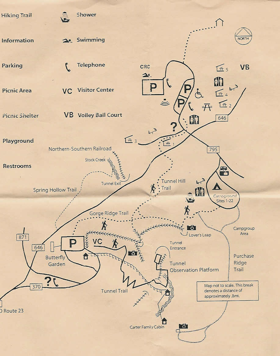
The natural tunnel is a dark, dank, kind of scary kind of thing, and the southbound trains come out of it like light out of hell. The noise of the trains is transcending, as it reverberates within the tunnel, and then explodes within the walls of the gorge. This is Steven Spielberg stuff.
When you're finished being impressed with the creek-level tracks, look up-up-up-up at the Lover's Leap and other battlements way overhead. You need to be here in winter to see and fully appreciate the geologic marvel you're within. This place is really special.
Back to the Site Listing Back to the top
Natural Tunnel -- Staging Area. Continuing south on VA-871 from Tunnel Hill State Park, you'll shortly see multiple tracks and an obviously railroad owned and operated area to your left. This I call a staging area, as it has the look and feel of a MOW area that pre-positions materials for snow, maintenance, etc. While shots both north and south from the west side are "1", there are no photo ops from the east side of the tracks.
Back to the Site Listing Back to the top
Clinchport -- Clinch River Bridge. Further down VA-871, the road will end at a T with US-23. Take a left, and you'll stay fairly close to the tracks, but they are treed in, and you should just continue south on US-23 until the junction of VA-65. The reason you have to go back north on VA-65 is that we have finally run into the monolith known as Clinch Mountain. This beast goes from southwest to northeast for dozens of miles, and alters everything up here -- railroads, roads, school districts, post offices, etc, etc. This is the major geographic feature in this part of southwestern Virginia. Take a left onto VA-65, and go north until you see the major NS bridge over VA-65 and the Clinch River. The railroad is mostly north-south here, so take the following photographic ratings literally: W1/E1. Yes, on the east you'll have to shoot between the trees lining the river, but that shouldn't be a problem. As far as from the west is concerned, watch the dogs (they just want love), and be creative. This is an excellent photo location, and I don't understand why we don't see more photos from it.
Back to the Site Listing Back to the top
Speers Ferry -- Copper Creek. The most famous portion of this tour, at least as far as railfans are concerned, is the crossing of Copper Creek. Both the Clinchfield and Southern come south on the east bank of the Clinch River from the Clinchport area. Bear in mind that the Clinchfield was a much more modern-designed and built railroad (ca 1910 vs ca 1890) than the Southern, and that it tended to go thru and over, rather than around. That is obvious in the juxtaposition of the two railroads at Copper Creek.
Return back to US-23 via VA-65, turn left, and head south. You'll see the broad Clinch River on your left. For now, ignore the panorama of the high Clinchfield viaduct over the Copper Creek valley, and continue south to a left onto VA-627. VA-627 is a narrow, one lane gravel road. Note that once on VA-627, there is only one (very) small passing pull out all the way back to the viaduct and bridge. Slow down and drive very carefully. If the RBBB Circus train is coming, ignore it; just get your butt safely to the viaduct area.
Once you're in the vicinity of the viaduct, there will be no doubt that you're there -- just look straight up. The Clinchfield soars far, far overhead. Photos are virtually a joke. On the other hand, photos of the railroad we're following, the ex-Southern, are quite possible. You won't get a TRAINS cover shot, but you can get some decent material from the east (there is nothing from the west, unless you're in a stationary boat). You must be patient, have a wide angle lens, and shoot during the winter. In between trains, Copper Creek has been know to yield more than a few fish. Why do you think there's all that parking in the area? It's not because of railfan activity!
Back to the Site Listing Back to the top
Speers Ferry -- Viaduct Panorama. Go back out VA-627, and take a right to go back north on US-23. This will get us the panoramic shot of the viaduct and NS bridge over Copper Creek. This is definitely an afternoon shot, and one that is best in the winter. There are several sections immediately east of US-23 that are becoming treed in (so bring lopping shears and even a small chain saw), but there are also a few wide open areas for pix.
You'll notice that I took you beyond this point to visit the area of the viaduct itself at Copper Creek, and then took you back here to the panoramic view. This is simply because there is a minimum of turns by doing it this way.
You'll also note that 14,000 ton coal trains look like z-scale models on the viaduct, and the coal trains on the NS don't look much bigger. That said, I doubt the crews on the NS get nose bleeds like those of the CSX far overhead! Eastern mountain railroading at its finest.
Back to the Site Listing Back to the top
Speers Ferry -- Troublesome Creek. It is roughly at this point in the tour where the builders of the railroad began a major detour around Clinch Mountain -- that large object just to your south. The railroad will go due east, swing thru a gap east of Gate City, go back west to Yuma, and then finally rejoin it's southwesterly bias. Twenty years after this railroad was built, the guys building the Clinchfield, armed with much better technology and plenty of money, simply punched a hole thru the mountain.
We get hung up on super-duper fancy railfan sites or photo ops sometimes, and I think we overlook some very fine spots because of our hang ups. O. Wilson Link photographed unspectacular locations in spectacular style. Here's a suggestion for those who want to shoot the Great American Train Picture in a bucolic scene.
Coming south from Clinchport, the ex-Clinchfield will go south over the tracks towards the tunnel, and the Norfolk Southern will swing 1335° to the east to run parallel to Troublesome Creek, north of Clinch Mountain. There are acres upon acres of wide open shots to the south from US-23 of the railroad, and after VA-870 peels off to the south of US-23, there are lots of shots over houses nestling close to the tracks. Yes, these are south-facing shots, and you'll have to contend with the sun, but Mr. Link did it in the dead of night, and you guys with sophisticated digital cameras can make magic with this stretch of the railroad. I think this is a potentially rich mining area for creative photographic artists. As with virtually all photography and fanning up here, winter is, by far, the best season.
Back to the Site Listing Back to the top
Jennings Mission -- Watkins. It's tough to pinpoint a specific town in this area, but DeLorme identifies the place as Jennings Mission, and we've got 3 spots worth mentioning thru here. As you travel east next to Troublesome Creek, you'll see it go to the south, and after a short period, you should take VA-870 to the right. You'll cross Little Moccasin Creek, and see the north (compass west) end of a passing siding. This is Watkins. Depending on the season, you get N2-3, but definitely an S4 because of private property. The dogs try to make noise, but really don't have their hearts in it.
Back to the Site Listing Back to the top
Jennings Mission -- Boone. This is the south (compass east) end of the siding that began back at Watkins. You can go over the tracks at Watkins, take a left and continue along the south side of them via VA-789 . Eventually, you'll come to a 90° turn to the left, to go north over the tracks at the east (timetable south) end of the siding at "Boone".
This is a darned good photo site, at NE1, SE1, SW1, NW4. It's a drop dead photo location almost any time of the day.
Back to the Site Listing Back to the top
Jennings Mission -- Little Moccasin Creek. Between Boone and on into Gate City, there are several photo spots from the north of the tracks, although there are none from south of them. That said, there are so many nice spots from the north that they earn a mention. All along VA-870 east of Boone, you'll see wide open photo spots, and depending on the time of day and season, you might just get a really nice "keeper".
Back to the Site Listing Back to the top
Gate City -- Ena/Ana/Una. As you enter Gate City via VA-870, you'll go under US-23, and Ana Street will be on your right. Take it, and Ena Street will be to the right, and Una Street will be to the left ( I think, but all this is most complicated. Just use your railfan sense to stay parallel to the tracks.) Great pix all day, every day, from the south. If you know a train is coming, this is the place to be in Gate City.
Back to the Site Listing Back to the top
Gate City -- Quarry Lake. Just a bit beyond Ana Street is a lake that now occupies what used to be a quarry. It is deep green, and must be a zillion feet deep, but it's on the north side of US-23Business (which VA-870 became once it entered Gate City), and has nothing to do with this tour. However, south of the lake, there is a street over the tracks (west of Snodgrass Street), that branches off both east and west, and offers excellent photo ops. I should also mention that the eastern end of Una Street (?) has a crossing that is also most excellent. Sorry, but you'll have to do your own map work here. This is a little jumbled, and it's easier for you to visualize it than it is for me to verbalize it.
Back to the Site Listing Back to the top
Gate City -- Grogan Park. Well, the next location isn't a majorly great railfan location, at NE3, SE4, SW3, NW3, but it's a great place to take the kids and let them run off some steam. There are also picnic areas, a walking trail, rest rooms (repeat: rest rooms), a jungle gym for the kids, etc, etc. It's really a nice municipal park. From US-23Business, take a right onto Park Street, and then another right onto Park Drive (study the map, and don't be surprised if the street signs are missing or different). This is a lovely municipal park, and Gate City should be proud of it.
Back to the Site Listing Back to the top
Gate City -- Parking Lot. You can continue east on Park Street, beyond Park Drive and Grogan Park, and there are some crossings/areas that I've not detailed. Park Street will smudge into Water Street West, which will lead to Depot Street, and an obviously railroady area, but it is posted, and serves as a glorified parking lot for NS equipment and trucks. This is NARL.
Continue northeast on Water Street West, and then take a right onto South Moccasin Avenue. North of the tracks is a huge municipal parking lot, I don't know why the big lot is here, but it offers excellent views of the tracks, and is highly recommended. The downside is that the viewing is all to the south, but creative photographers with digital cameras can probably work around the south-facing problem.
Back to the Site Listing Back to the top
Gate City -- Magnolia Avenue. Full disclosure: This is one from the map, and not on the ground research, as I completely missed it when I did my map prep and on-the-ground research, so take it with a grain of salt. Continue northeast on Water Street to US-23Business, and then take a right. You'll be immersed in the best fast food area of the entire tour, so far -- this was observed, and is not the subject of this railfan location. However, somewhere in here, Moccasin Street goes off to the right, and just after the tracks, Magnolia Avenue goes to the left (east). I did not see this on the ground, but I expect it's a darned good photo spot. Please let me have your feedback.
Back to the Site Listing Back to the top
Weber City -- Dogwood Drive. As you leave Gate City, US-23 Business will merge into US-23. MapQuest shows a crossing north of US-23 on VA-619, but I did not observe that one. You are now rounding a low spot in Clinch Mountain cut by Little Moccasin Creek, and the builders of the Southern used it to get "across" the mountain, as did the Indians centuries earlier, the road builders, etc. Two major highways, US-23 and US-58 use the gap, and you are never far from the creek or railroad. The latter goes over the highway on a NAG/NARL, and then both bend to the southeast to flank the mountain to its south, prior to heading south into Tennessee.
You'll very shortly enter Weber City, and the tracks are right next to the highway all the way thru town. Unfortunately, the crossings are very narrow and steep, and none are railfan locations. There is also a very heavy pole line between the highway and railroad. Go over one of the crossings, and turn left onto Dogwood Drive, which parallels the tracks on the north. Photos are somewhat difficult because of the sun, but viewing is excellent all along the street.
Back to the Site Listing Back to the top
Weber City -- Smith. As you get to the south end of Weber City, Dogwood Drive goes quite a ways southwest along the tracks, and you might want to check it out. Otherwise, take a left onto Wilmeth Street, cross the tracks, and take a right onto US-23. Then look for, and take a right on, Yuma Road. Yuma will get you quickly back in the country, and you should watch the railroad off to your right and above you. When you get to a point where two dirt roads go north, one diagonally to the right and the other to the left, go up the left facing of the two. You'll get up to an area with "Smith" electronic tower off to the right, and the beginning of the Yuma siding and yard even further to the right.
I have been told that there are no manifest freights north of Frisco Yard, and that Yuma Yard exists to increase the length of loaded coal trains that have come down from the mountains. The grades south of Yuma are obviously less strenuous than those around Andover and like further north. However, I've seen lumber racks, covered hoppers, and other general freight cars in the Yuma Yard, so I'm not so sure what I've been told is correct.
As this is railroad property, it is not a railfan location. It is only included herein as a point of reference. After Yuma -- South End Yard, the next two locations are off railroad property and are much better photographic locations, so there is no need to visit Smith, except to be able to say "Been there, done that".
Back to the Site Listing Back to the top
Yuma -- South End Yard. Here is another point of reference site, and like Smith, is not considered a railfan location. However, if you wish to ask for permission to photograph trains at either Smith or Yuma Yard, this is the place to do so. Continue west on VA-614, and watch for VA-960 heading steeply uphill to the right. Take it, and it will take you up, up, up to the yard office and employee parking area. If you really want to take pix anywhere in the Yuma Yard area, you MUST get permission from yard personnel. Norfolk Southern very definitely protects its property rights, and you have to be respectful of their rights.
Back to the Site Listing Back to the top
Yuma. VA-614 will get quite close to the tracks, and then will bend fairly sharply to the southwest. At this bend, you'll see some trash dumpsters at a "convenience center" on your right. Bear right, pass the dumpsters, and head for the church and cemetery. Park in the area, well back from the tracks. The end of the Yuma siding is at the "Yuma" electronic tower just to your left. There are east facing signals that are easily observed, but the west facing signals west of the switch cannot be read without trespassing on the right of way.
This is a good photo location, as the tracks are mostly east-west, and there is plenty of wide open area well back from them.
Back to the Site Listing Back to the top
Frisco Yard -- North End. As you head further west on VA-614, look for VA-639 to your left and take it. After the end of the Yuma siding, the railroad bends sharply south to work thru a fairly wild area. Clinch Mountain, as it has ever since the Copper Creek area, dominates the geography here, and at the end of Yuma siding, the Southern's detour around a large part of the mountain has ended. You'll be far from the railroad for several miles, so slow down and enjoy a lovely, bucolic drive on this back country road. Believe me, you won't be able to speed on it, so you may as well enjoy it. Possum Creek has more curves than seems reasonable, and you'll see a few of them.
There is a NAG/NARL crossing after the last crossing you'll make of the creek, and then another trestle that is treed in will appear. Shortly after the latter, the scene will almost magically open up, and you'll be at the north end of Frisco Yard. This point is where the "o" in "Frisco" on the DeLorme is. The bias of the yard is almost dead northeast/southwest, so photos can be had, but you'll have to work for them. You're wide open on the west side of the yard throat, but there is no access to the east side.
Frisco Yard is fairly small, as it's purpose is not to handle coal trains -- that's done up at Yuma Yard. Frisco primarily exists because of the Eastman Chemical and related industry complexes in Kingsport. You'll see CSX transfers, NS locals arriving, and NS manifests arriving and being made up. A small yard, indeed, but a very important one for Norfolk Southern.
Back to the Site Listing Back to the top
Tennessee
Frisco -- Yard. If you are just starting the tour here, we'll start you in a logical place, one virtually at the Tennessee and Virginia border. From I-181 in Kingsport, go north to the last exit, where you must either go to the right onto TN-36, or left onto US-23. Take the right, and just a short while later, a left onto TN-346/Carters Valley Road. This may look like a minor road, but in terms of traffic, it's the major east/west road in this area. After 3 miles or so, look for Waycross Road veering off to the right. If you're observant, you'll see a bent "Frisco Yard" green sign with white letters at the intersection.
Take Waycross Road, and then take a right onto Underpass Road, and just before the tracks, take another right to go up the very steep drive to the yard.
If you are continuing this tour from the north, and are coming from the north end of Frisco Yard, continue west on VA-614, which will shortly T at VA-804. Take the left, and you'll almost immediately be in Tennessee. In the latter, this road is Underpass Road. Immediately beyond the NS underpass, there is a road going up into Frisco Yard. Before you get to this underpass, you'll see a fairly large, yellowish building standing above the yard. This is the well-known Frisco Yard office. The turn from Underpass Road up to the yard is impossible from the north, so continue on, turn around somewhere, and come back, take the right, and go up into the yard parking area.
This location is on private NS property, so I'm going to give you some necessary advice: This is a most interesting place to visit, and I do advise driving up and looking at the unique yard office. If you shoot railroad structures, this is a must have, indeed. Take your photo from the car, and then leave. If there is a train pointing toward you, you can also shoot the lead engine from your car, but do not drive down into the yard area. Turn around and leave. If, when you enter the yard office area, there are railroaders present and working, don't even take pix from your car. Just turn around and leave.
The yard is the northernmost point at which you will see manifest freight trains. Everything going north or coming south from this point is coal only. The reason the yard is here is not because of coal, but the large amount of manifest freight exchanged with CSX (ex-Clinchfield Railroad), and gathered by NS at the immense Eastman Chemical complex in Kingsport.
Back to the Site Listing Back to the top
This completes the Saint Paul - Frisco Segment of Frograil's NS Appalachian Tour. The next segment, Frisco - Knoxville, has been completed to Bulls Gap, and is here. Information about the overall tour is here.