
Central Of Georgia
Millen - Savannah, Georgia

Introduction
This tour is part of the Central of Georgia Tour from Birmingham to Savannah. The tour overview is here.
The segment represented here is to eventually cover the territory between Millen and Savannah. Millen is northwest of Savannah, and an important point, in that trains can go west to Macon, or north to Augusta, or vice versa. The text is complete between Springfield, Georgia, and the northern yard throat of Dillard Yard, in northeast Savannah.
Contents And Navigation:

WHAT YOU WILL FIND HERE: From a particular starting point, each segment of this coverage will allow you to follow the instructions given, drive to a railfan site, then to the next, etc. etc. Traffic levels and patterns will be given, and the photographic/ lighting considerations for each site will usually be mentioned. You'll be told about area attractions, such as tourist and historic sites, as well as hotels and restaurants which are trackside or otherwise worthy of note. In short, you'll be able to plan an entire family or railfan-only outing or even a vacation from this guide, as it is completed in the months to come.
WHAT YOU WILL NOT FIND HERE: This is a railfan guide, not a photo collection. There are already many excellent and enjoyable railroad photo sites available, and one more really wouldn't add much value to the general railfan. Besides, photos take up a lot of memory, and your humble Webmaster has to pay for memory.
You will not find fancy graphics, as this is a tour guide, not an exhibition of HTML or graphics expertise. You'll be able to load these pages quickly and print them without waiting a week for each page to print. Also, you'll conserve toner in the process.
Contributors
Major contributors to this effort include:
Train Gif Artists. Train gifs add life and color to this page, and take almost no time to load. I stick these gifs in whenever I get the urge -- there is no rhyme or reason, I just like them. You can see hundreds and hundreds of train gifs by clicking on the Train Gifs navigation button at the top of each Frograil page.
Tony Hill, Webmaster. All text within this segment. Tony is the guy who makes Frograil go. Any singular first person pronoun used in this document refers to Tony, unless otherwise specifically indicated.
Help
If you'd like to contribute to this, or any other tour, please contact me at webmaster@frograil.com, and let me know what you'd like to do. We'll work together: You supply the data/info, and I'll do the HTML stuff and upload it. You'll get a chance to review the fruits of your efforts before the general public sees the finished product, so you can let me have your corrections, additions and changes.
Supplemental And Back-Up Data
The Railroad -- General. Norfolk Southern's ex-Central of Georgia here in the coastal plain is quite different, geographically, from the portion way back across Georgia and Alabama to the west. It's mostly coastal plain, wide open, flat viewing, and that's pretty nice for those of us who are used to the Piedmont or the mountains. The railroad is single track, with only a few sidings between Millen and Savannah's Dillard Yard. As is normally the case with Norfolk Southern, the physical plant is in superb condition. This is dark territory using Track Warrant Control for train movements over the line.
The Railroad -- Geography. From Springfield south to Savannah, this is the Coastal Plain. There are no hills, and trains roll right along. The bias of the tracks is a pretty relentless northwest - southeast, at times being almost north - south.
The Railroad -- Traffic. It appears that average traffic is about 8-12 movements per 24 hours, mostly manifest and intermodal. Tommy Parker has given us info to the effect that there are 10 scheduled movements per day, so factoring in typical railroad variability, I'll use the 8-12 figure.
Mapwork: Much of the tour is not easy if you have no detailed map for back country roads. I definitely recommend you get a DeLorme Atlas & Gazetteer, study it before your trip, and copy pertinent pages for your field work. You can find information here about Railfan Maps that are available.
Photographic Considerations: As I've done in several Other Tours, I've attempted to rate the photo fields for all 4 quadrants of many crossings detailed in the tour. The following format is used: NE2, SE1, SW4, NW4, where you go clockwise around the quadrants from northeast to northwest, and numerical ratings, from 1 to 4, with a 1 being excellent, and a 4 being non-existent, are assigned. Note that I'm rating only photo field availability, not the photogenic qualities of the site. I'm a picture taker, not a photographer, and you guys who are good photographers will have to make your own determinations.
Security. This segment of the tour takes place in small towns and rural areas, at least until you get fairly close to Savannah. Muggings aren't a concern, but personal safety always is. The railroad is also very aggressive in protecting its own security. Do not trespass and you will have no problems.
Abbreviations. Some phrases are used repeatedly in this tour, so I've developed some standard Frograil abbreviations:
AG. An at-grade crossing.
NAG. A not-at-grade crossing. Unless I mention otherwise, these are usually not worth the time and trouble to drive to.
NARL. Not a railfan location. This is because of any number of reasons, such as lousy photo ops, dangerous, no shoulder on a NAG bridge, etc. As a general rule of thumb, it is wise to avoid NARL's.
WEBMASTER'S NOTE: I do not recommend or condone, walking along the tracks, as this means trespassing or exposing yourself to danger. You will have to be creative, in some instances, to avoid trespassing while getting to the detailed locations included herein, but you will either have to be creative or not visit those sites. At no point in this tour guide, or any other tour which is part of Frograil, is it recommended that you trespass or expose yourself to danger. If you are a fool and have a leg cut off (or worse), don't come crying to me: You have been warned. Trains are big, powerful, and often surprisingly quiet. Don't end up being a statistic.


Millen -- Savannah, Georgia-- Railfan sites
Springfield -- Defect Detector. Springfield is about 20 miles north northwest of the northern area of Savannah. The tour temporarily begins at the intersection of GA-21/Laurel Street and GA-119 in downtown Springfield. GA-21 is the old street thru downtown; GA-21Bypass is not the same road. From the intersection, go southwest on GA-119, cross the tracks, turn right on Railroad Avenue and park. There are several places close together to view trains in the area, and I'll give you these. Understand that even though they are close together, the "feel" and viewing at each of them are quite different.
You'll see a dragging equipment detector, and this is MP SA 24.6. You'll hear this talking detector for several miles to the south as you wend your way towards Savannah and Dillard Yard. Photos are N3, S1, and are given assuming you've moved north from the crossing itself. Note that the tracks for virtually all of this tour are on a northwest - southeast bias, so take compass directions with a grain of salt.
Springfield -- Holy Trinity Lutheran. Go back to GA-119, take a left to go back over the tracks, and just past the tracks, take a right and park in the large parking lot for Holy Trinity Lutheran Church. Obviously, if there is a church function going on, park elsewhere. Viewing from the parking lot is excellent. Overall photo ratings at the crossing are NE1, SE1, SW3, NW2
Back to the Site Listing Back to the top
Springfield -- MOW Spur Area. Leave the parking lot, re-cross the tracks, and take a left onto Railroad Avenue. Drive to West Second Street and park. This is the location of what used to be a short siding -- probably used as a team track in the remote past. The north end of the siding and the switch are long gone, but the southern end is still extant, and is used for MOW storage occasionally.
Photos are quite good from the east: NE1, SE1, SW2, NW4. Note that the southwest quad now has decorative trees planted by the city, so that viewing angle has largely been ruined.
Springfield -- Ramsey Street. Go back up to GA-21/Laurel Street and turn right to go south. As you're leaving town, take a right onto Ramsey Road. The crossing is just a short distance, and is not as good a location as the preceding few spots. However, if you need to get trackside in a hurry, this will do the job. NE2, SE3, SW3, SE2.
Back to the Site Listing Back to the top
Springfield -- Webb Road. Continue south on GA-21/Laurel Street, and you'll veer to the east and join GA-21Bypass where the latter ends/begins. About 1/3 - 1/2 mile past this intersection, look for a road going off at a very sharp angle. This is Ralph Rahn Road, and you need to be on the lookout for a very minor road to the right, Zettler Road. Take this back towards Springfield. You'll come to Webb Road, and a crossing. Park east of the tracks. Photo ratings are gaudy: NE1, SE1, SW1, NW1.
With very little noise, wide open photo ops, and a mostly country setting, this is the best location in the area. Set up your lawn chairs, get out the cold drinks, and enjoy a fine spot.
The MP SA 23 marker is just north of the crossing.
Rahns -- Ralph Rahn Road. Retrace your route back to Ralph Rahn Road, take a right and go to the crossing. The photo ops here are almost as good as at Webb Road, but the road is busier: NE1, SE1, SW2, NW1.
Rahns. Continue past the crossing, and look for a minor connector road veering off to the left, and then another left onto Race Path Road. This will wander around and eventually get to the tracks, turn 90° to the south, and parallel the tracks to end at Rahn Station Road.
[Webmasters Note: Between Springfield and the intersection with Rahn Station Road, we've been enjoying a bucolic country drive. At Rahns Station Road, this ends. We are now entering the Savannah area, even though it still looks quite rural. The roads are busy from here on in, so take extra care.]
Rahn Station will take you to a crossing where there must obviously have been a station once upon a time. Rahns is a so-so crossing at NE2, SE3, SW3, NW2.
Back to the Site Listing Back to the top
Blandford. Go south on Rahn Station Road all the way to a left on McCall Road. Drive to a T at Blandford Road and turn left; the crossing is immediately ahead. Immediately to the south of the crossing is a station sign for "Blanford", as the railroad spells this place's name.
Incidentally, about a mile or so north of Blandford is the site of Sepco Junction, where a spur heads to the northeast to a power plant. There is no public access to the junction. However, it's important to this tour, as NS uses the junction to deliver a coal train to Savannah Power at the end of the spur about 2-3 times per month. You will not see this train in Blandford or any other point south of the junction. The cars carry SAVX reporting marks. Thanks, and a tip 'o the Frograil hat to Tommy Parker, who brought us up to speed on the Sepco Junction information.
There are 2 tracks, with the west/south track a very infrequently used siding/storage track. The X rather than the + layout of the crossing yields an opportunity to get decent pix at virtually any time during the day. NE3, SE1, SW2, NW1-4. The variety in the northwest quad results from the fact that there is a storage area for old ties, etc. Depending on the amount of junk around, you can have everything from great viewing to no viewing.
Coldbrook. Cross the tracks, and McCall Road once again appears on the right. Take it and drive all the way to Golden Road. There is a crossing shown on MapQuest (but not on DeLorme) via a road going to the tracks, but I did not attempt to follow it. Anyway, you will probably be surprised to eventually see a set of cross bucks and crossing gates, as you know the railroad is well behind you to the west. This is CSX coming down from Fairfax, SC. Take a right and parallel CSX south to the crossroads of Exley. Take a right onto Goshen Road, and take it to a crossing with the NS line we're following.
This one is also an X, so pix can be taken of both north and southbounds almost any time of the day. NE2, SE3, SW4, NW1. Goshen Road is majorly busy. There is a defect detector just north of the crossing, at SA 14.7.
Back to the Site Listing Back to the top
Meinhard. From Coldbrook, retrace your drive back up to Exley, and continue via Goshen Road all the way to GA-21, and take a right to head south. GA-21 has now become a major thoroughfare heading into Savannah proper. You will notice an unbelievable amount of containers going every which way. You are just west of the Port of Savannah's Port Wentworth area.
Take a right onto GA-30, and cross both the CSX and NS tracks (in that order). Take the next left onto Meinhard Road. This will take you to 2 crossings. The closest (i.e., the one on the west) is NS, and the easterly one is CSX. The NS crossing is rated NE1, SE2, SW3, NW3, and is pretty decent.
Savannah -- Gulfstream Road. Continue east on Meinhard Road to a left on Hendley Road, which will take you to GA-21 again. Turn right, and you'll very shortly go up and over the CSX A-Line. Pass up Jimmy Deloach Parkway, as its crossing is NAG/NARL. South of JDP, you'll see a spindly-looking railroad bridge going overhead; this is the NS line heading over to Port Wentworth and the Port of Savannah. It must be much stronger than it looks, because it carries a lot of traffic.
Shortly after this overpass, look for a major intersection, with Crossgate Drive on the left, and Gulfstream Road to the right. Take the right and watch out, as seemingly every container ever created is being driven around in a bewildering manner. Throw in the fact that you've got to cross the CSX double-tracked A-Line, and you've got a place that is not citizen-friendly. Yikes!
Persevere, however, and you'll soon cross the CSX tracks coming down from Fairfax, SC. The next tracks you'll cross are those of NS, and they're somewhat confusing. There are two tracks, fairly widely separated. Remember the bridge going over to the port mentioned 2 paragraphs ago? The first track (the eastern most) is the line going over to the Port of Savannah via that bridge. The second is the main line going up to Springfield and Millen. The photo ratings for the east track are NE3, SE3, SW1, NW3, and those of the west track is NE3, SE1, SW1, NW4.
This is a cool location, but it is very noisy, as Gulfstream Road is quite busy, and the airport for the Savannah area is just west and south of you. This is also a "sensitive" area, so exercise your best ability to remain inconspicuous. Keep your crossings of Gulfstream Road to an absolute minimum.
Crossovers and sets of signals for each track are a fairly short distance to the south.
Back to the Site Listing Back to the top
Savannah -- Port Junction. Go east of the Gulfstream crossing, and take a right onto the unsigned first right. There is a sign to the Coastal State Prison. After just a few hundred feet, you'll see the electronic tower casing for the Port Junction interlocking on your right. Now, imagine that you're standing on the road looking at this electronic tower: There are pines just to the north and just to the south. You'll have to walk north or south of these, respectively, to get decent shots. Assuming you do so, the photo ratings are E1, W4.
This is a sensitive area, not because of the airport, but because of the "guests" in the state pen to the south of you. For that reason, I think it's probably best as a weekend location. Personally, I think it's a very good morning spot. This is MP SA 7.3.
Savannah -- Big Hill Road. This road was obviously named for your famous Webmaster -- well, maybe not. Anyway, it's a unique road in a unique area, and a darned good railfan location. From the road leading to the prison, go back up to Gulfsteam Road, take a right, and go back out to GA-21. On your way south, pass up GA-307, as it is AG but NARL because it's just too busy to be a railfan location. Take a right and at Big Hill Road (a rather minor road, to say the least), take a right. You will find yourself in the midst of a trailer park, without a clue as to where the road actually goes. Go to the southwest, slowly, and the road will reveal itself. In fact, it will wend past a lovely church, some nice ball fields, and several comfy homes.
After crossing the A-Line and the CSX line coming down from Fairfax, SC, it will finally cross the NS north Dillard Yard throat. Park in the area; photo ratings are NE3, SE1, SW1, NW2. There are crossovers and defect detectors north of the crossing. You can take all the pix you want from the road, but do not venture north or south of it, or you will become very popular.
Back to the Site Listing Back to the top
Savannah -- Central Junction. Between Big Hill Road and the south end of the yard, there is no public access. However, I will give you one south-of-the-yard location, just so you can say you've been there and done that. I can't help you with the T shirt, however.
In Europe, all roads may lead to Rome, but in Savannah, all railroads lead to Central Junction. Historically, four major railroads crossed here: Atlantic Coast Line (now the CSX A-Line), Central of Georgia (abandoned), Savannah and Atlanta (now NS main to Macon and Augusta), and the Seaboard Air Line (now the CSX Augusta line). The Central of Georgia may be gone, but the other three lines are wide open. All of these lines come together under the US-80/GA-26 overpass.
If you have been following the NS tour from the north, just get back to GA-21 and take a right to head further south. Note that GA-21 is swinging steadily to the east to become southeasterly, but the tracks are still slightly northwest - southeast. GA-21 will become an interstate, I-516, and you should take the first exit to head west on US-80. When the road rises up, look to the right, and you'll see the junction laid out just north of the overpass. Actually, this location may physically be in Garden City, but to keep it simple, we'll consider it to be part of Savannah.
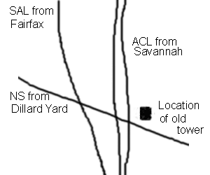
This crude drawing has some obvious flaws, but will do to describe the layout. You are standing on the overpass looking northwest. From the west side, the first track is the NS (ex SA) line coming out of Dillard Yard, the second is the CSX Augusta line (ex-SAL), and the 3rd and 4th tracks are the CSX A-Line (ex-ACL, they are parallel, not sloppy like the drawing!). You might consider some down on shots from the US-80 overpass, but it's really busy, and you'll need to be extra careful. Don't be surprised if local law enforcement runs you off, although there really is a pretty good shoulder on both sides of the bridge. The south side looks into the sun, and there is lots of road traffic, so don't consider walking back and forth across the bridge.
After the junction, you can take the first right onto Junction Avenue, then right onto Louisville Road, and drive towards the tracks. The area doesn't seem to be posted, but it is quite difficult to tell where railroad property begins and ends. The rule is to stay well back, and you'll probably be OK. This seems to be a fairly safe area, but I'd certainly suggest you have at least one male friend with you, and definitely suggest you depart well before dark. In this day and age, you'd better be well back from the tracks, or you'll probably end up being a guest of the city of Savannah (or Garden City) for the night. This is definitely an afternoon location, as there is no way to get to the east side without blatantly trespassing, and the photo angles are lousy anyway. As you can probably tell, I'm not fond of this area, and personally don't consider it a railfan location.
Well, it's obvious that Frograil needs some help west of Springfield, and east of Columbus. Can you supply some of the necessary data? e-mail me at webmaster@frograil.com, and maybe we can make something happen.