
NS Tidewater to Lakes Railfan Tour
Pocahontas Division -- Bluefield - Williamson, WV

Introduction
When all is said and done, there probably never has been a more consistently profitable railroad in North America than the Norfolk & Western Railway between Norfolk, Virginia and the coal fields of far western Virginia and West Virginia. As a vital piece of today's giant Norfolk Southern Corporation, the line is seeing less coal traffic and more of most other traffic, such as intermodal, manifest, and unit grain trains. This tour will take you, point to point to point, from Bluefield to Williamson, West Virginia. It is part of a much bigger tour, from Norfolk to Sandusky, and you can find out about the overall effort here. The segment between Bluefield and Mohawk (
Contents And Navigation

Contributors To This Tour
Markolf Gudjons, text between Bluefield and Iaeger
Fred Burton, on-site tour guide and data provider, Bluefield - Iaeger
Train Gif Artists. Train gifs add life and color to these pages, and take almost no time to load. Tony stuck these gifs in whenever he got the urge -- there is no rhyme or reason, he just liked them.
Tom Hullett. Showed Tony Hill through the Bluefield area, resulting in 8 new locations along this tour.
Bob Eisthen, Shane Miller, Marcus Neubacher and others, supplemental data.
Tony Hill, retired webmaster and data provider -- the guy who made Frograil go.
Martin Beran, a Michigan railfan who used the tour over the Easter weekend n 2012 and provided some updates and new details.
Help
If you'd like to contribute to this, or any other tour, please contact me at webmaster@frograil.com, and let me know what you'd like to do. We'll work together: You supply the data/info, and I'll do the HTML stuff and upload it. You'll get a chance to review the fruits of your efforts before the general public sees the finished product, so you can let me have your corrections, additions and changes.
Supplemental And Back-Up Data.
The Railroad. Between Kellysville and Mohawk, the railroad shares two attributes with the Clinchfield Railroad and the Chesapeake and Ohio Railway's James River Line. All three were built to haul coal in massive quantities, and all three were masterfully engineered and constructed. This ex-N&W main line twists and turns between mountains, through valleys and gaps, and along rivers.
Do three things to fully appreciate the magnificence of this railroad: First, drive all over the area. You'll be impressed with the ruggedness and inaccessibility of most the area. You'll be impressed with the fact that nothing wider than about three yards is flat anywhere around here. Second, stand close to trackside, and listen to a 12,000 ton coal train go by. It's amazingly quiet. Superior roadway elicits superior train movement. Third, as you take this tour, look at something other than the roadway and trains. Look at the entire picture. Study the bridges, culverts, tunnels, grades, etc., etc. Nothing on this line was built to be inexpensive or temporary. Stand under the high bridge in Coopers, and if you're not impressed, you need another hobby.
Traffic. There's lots of it. As the high-sulphur coal of Appalachia is being replaced with low-sulphur coal from the Powder River Basin, and as United States coal exports are being hurt by a strong dollar, there is less coal being shipped over the line. This is probably not a temporary trend. On the other hand, whole unit trains of autoracks and grain are on the increase. Manifest traffic is strong, and there is growing intermodal volume, also. You'll probably see 2-3 trains per hour.
Life-support. You're going to be in the mountains, not the east or west coast. Don't plan on touring and watching trains all day, and then finding the friendly neighborhood motel and flopping. They are few and far between. Same comment with regard to food, gas, water, etc. Do some study and preparation before you get there, and you'll enjoy yourself much more. Really, before embarking on this tour, you should get very familiar with the tour guide home page, which has lots of solid info you will want to digest before you head out.
There is one particular place that does cater to railfans, the Elkhorn Inn in Landgraff, on U.S. 52 adjacent to the NS main line.
There are also fast food and chain restaurants in Bluefield along with motels. From Bluefield, Va., take VA 102 (S. College Ave.) south for 1.25 miles, then turn left. Go a half-mile to Commerce Dr. and turn right; this street has several restaurants and runs into U.S. 460. Take this highway east and there will be other restaurants and motels along the highway and on surface streets off the highway. There are also quite a few choices for food and lodging in nearby Princeton, WVa. at the junction of U.S. 460 and I-77. Martin Beran also reports that the Wal-Mart in Kimbal is a good point for restocking and that there are several fast food places around Welch.
Driving the area. All highways and roads mentioned, including local roads, can be negotiated by normal cars. However, some of the gravel roads leading up or down embankments can be pretty rough on your family sedan. Decide for yourself BEFORE you send your car careening down a grade -- remember, you've got to get back up! Four-wheel drive is not a necessity, but good ground clearance and sturdy tires and shocks are. There's a reason so many people here drive pickup trucks. Martin Beran says if possible come with a pickup truck or rent one for the tour. The bed is a nice platform for taking pictures as well. Two feet more of ground clearance can make a huge difference.
The county roads were built closely following the natural topography. As a result, they twist and turn heavily and have significant grades. The locals know the roads by heart and drive accordingly. Expect to frequently meet coal dump trucks that move slowly and often block the whole width of the road. Bottom line: if you don't know the road, don't push it. Do not try to chase trains on CR-7, it will end in tears (or far worse)! Chasing is possible only on US-52, and even on that road, chasing is difficult, because many of the trains are surprisingly fast. We suggest you let them come to you.
Mapwork: Much of the tour is not easy if you have no detailed map for back country roads. It is definitely recommend that you get a DeLorme Atlas & Gazetteer, study it before your trip, and copy pertinent pages for your field work. You can find information here about Railfan Maps that are available.
Local folks. Up here, you're not in Silicon Valley or the financial capitals of the northeast. Indeed, you're where rather limited options have produced some pretty tough survivors. This area of West Virginia has seen better times. The downturn in eastern coal business is due in large part to the availability of low sulphur coal from Wyoming's Powder River Basin, and the robustness of the US dollar. The economic consequences have been devastating. Many online communities are on the border of extinction (or may be already past that!).
This being the way it is, the hardy people living here are some of the nicest folks you'll ever meet. They have an open attitude and are more than willing to share stories and history, which in these valleys are almost always inextricably intertwined with coal and railroads. Often described as rednecks and hillbillies, these hard-working and level-headed mountaineers deserve respect in exchange for their generous hospitality.


Bluefield, WV - Mohawk, WV -- Railfan Sites:


The Tour
Back to the top Back to the Site Listing
[Webmaster's note: From here west to Iaeger, the text is largely thanks to Markolf Gudjons of Aachen, Germany, who toured the area in the late Spring of 2000. Also, Fred Burton and Tony Hill toured the area in August of 1999, and Fred's knowledge added greatly to the extensiveness of this data. In September 2006, Tom Hullett of Bluefield introduced Tony to eight of the sites in the greater Bluefield area.]
If you're continuing the tour from the east, you will be coming into Bluefield via WV 112 and U.S. 19, and you'll just continue on without having to make any adjustments. If you're just starting the tour, take the U.S. 52 exit from I-77, which is the first exit going north from Virginia into West Virginia. Follow US-52 right into downtown Bluefield to the yard area. The first specified locations, the bridges going over the yard, will require you to take a right onto U.S. 19, and head north (compass east).
Bluefield -- Grant Street Bridge. Getting shots of action in and around the yard in Bluefield is difficult, especially the eastern end. In Bluefield, one location is the Grant Street bridge, which is well into the yard from the east, but a good bit east of the engine facility. On the east side (only) of the bridge is a protected walkway, and it is safe. Do not, under any circumstances, try to walk out in the west auto lane to shoot movements from the west. There is no place to get out of the way of cars, and those cars appear very suddenly. They also make quite a racket on the steel decking, and you'll jump out of your skin the first time you hear one.
From U.S. 52 at the foot of the hill and opposite the yard, take a right onto U.S. 19. Do not try to park next to U.S. 19; rather, take a right onto Monroe Street and park in that area. Walk back to U.S. 19, take a right, and then walk out onto the pedestrian walkway on the east side of Grant Street.
The views are unobstructed and wide open, and you can get good shots of trains coming in from the east, as well as light power movements in both directions. However, you are relatively deep within the yard, so the yard action itself is somewhat limited.
There is a pretty good spot right across the Bluefield engine terminal at the intersection of Princeton Ave (U.S. 19) and Bland. Park on Bland and take care crossing U.S. 19. There are two parking spots (30 min. limit) right at the edge to the yard. Martin Beran was lucky and had an nice panorama of the engine terminal unobstructed by any trains.
There is also N. Mercer street bridge crossing the yard. It has pedestrian walkways on both sides and provide a good, unblocked view at the engine service area and the yard.
Back to the top Back to the Site Listing
Bluefield -- BSC East Lot. From Grant Street, go back to the west on U.S. 19, take a right on Mercer Street, and then a left onto Pulaski Street. Go until you must turn right onto Rock Street, and then a left onto Hill Avenue. Hill is the main street through the Bluefield State College (BSC) campus. You'll go past a large administrative building, and will see a large parking lot to your left. [NOTE WELL: Sometimes this lot will be virtually empty, while at others it can be jam-packed. If it's full, I advise you to avoid the entire BSC area, at least as far as parking is concerned. Park elsewhere and walk in, if possible.]
Drive to the extreme southeast end of the lot and park. You will be treated to an excellent panorama of the action on the near west end of the yard. You'll see all arrivals and departures, plus helper movements off coal trains going back to the west. This is an excellent place to watch trains, but it is not a photo location, as there are massive wires and other clutter between the hillside and the yard below, and the sun will be in your face almost all the time. Also, I'd suggest you not wander around a lot, as that may draw unwanted attention from the campus police. Ideally, this is a Friday afternoon to Sunday evening location, as are the other BSC locations we'll mention.
Back to the top Back to the Site Listing
Bluefield -- BSC U.S. 52 Lot. Go back up to the top of the parking lot, and follow the one-way arrows to the east. Take a left to go west on Hill Avenue. This turn is a wicked, more than 90°, and very much uphill turn. I found it easiest go simultaneously hit the gas, turn the wheel, and close my eyes. It worked, but I only had to do it once. You'll see the large U.S. 52 bridge going over the yard, but just before reaching U.S. 52, take a left into a fairly small parking lot. [Note: Same disclaimers as in the previous location.] The viewing situation is like the previous location, with lots of action, but continued wires, clutter and sun. You're farther west, however, so you'll see more helper action.
Bluefield -- U.S. 52 Bridge. From where your car is parked, just walk out on the bridge on the east side only. There is a protected walkway and it's safe, but there is also a tall chain link fence protecting the tracks. Digital cameras with small lenses will have no problem, but larger, sophisticated lenses will have all kinds of issues. There is excellent viewing all along the bridge to the east, but you cannot access anything to the west.
Bluefield -- BSC Dickson Hall. At the west edge of the BSC U.S. 52 parking lot, there is a walkway that will take you under the highway over to the college's Dickson Hall. There is a small parking lot there, but it is not recommended. Do not walk across U.S. 52. Walk away from the building down towards the tracks. To the east, there is no viewing, because the bridge is in the way. However, to the west, the viewing is terrific. There are no wires, and it's all wide open. Your viewing angle is slightly to the southwest, and the sun will remain a problem most of the time. The lawn is mown, and this is a great place to sit, relax, and let the train show play out in front of you.
Back to the top Back to the Site Listing
Virginia
Bluefield -- Depot Street. Continue west on U.S. 19 into Virginia and Bluefield, Virginia. This is the sister city of Bluefield, West Virginia, and is also a good place to watch trains. Close to downtown, turn right (north) onto Depot Street. Park behind the grave stone/monument company and enjoy good photo, off-railroad, locations virtually all day. As you look down the tracks to the west, you will see the junction of the mainline which swings off to the northwest, and the Clinch Valley main going down to Tazewell and St. Paul going off to the southwest. Let's go to this location.
Back to the top Back to the Site Listing
Bluefield -- Junction. This is the junction with the Clinch Valley District, which covers the NS (former N&W) main line between Bluefield and Norton, Va. Continue south on U.S. 19, and approximately 1/8 mile past College Avenue, there is a vacant lot with an old building foundation in it on your right. The lot is unposted, and because it's on the south side of the tracks, it should be good for photos most of the time. The single track going to the southwest is the secondary main line to Norton. The Clinch Valley district also includes the Dry Fork Branch between Cedar Bluff, Va. and Iaeger, W.Va. and the Buchanan Branch between Richlands, Va. and Devon, W.Va. It doesn't see the traffic that the Pocahontas route sees, but it's still a very important part of Norfolk Southern. The two main tracks heading northwest are the Pocahontas Division's main line to Williamson.
Bluefield -- Bluestone Interiors. When you get to College Ave./VA 102, take a right, go under the tracks, and look for a large fire department station on your right (yellow! engines). Opposite the firehouse is a sign for Bluestone Interiors. Take the left and go to the right, around the business. Drive very slowly, as the area is very rough. You'll go up around the north end of the property, and the railroad will be laid out in front of you. You'll see the Pocahontas Division tracks well, but you might need to be in the back of a pickup to see the Clinch Valley District track, which is already peeling off to the west.
Bluestone Interiors is in the large brick structure to the southwest. This is a pretty good spot to watch trains, but it's not a particularly good train pix location.
If you take a left on S. College Ave./VA 102, it will take you to the restaurant and commercial area outside of "downtown" Bluefield where you can get food, fuel, and supplies.
Back to the top Back to the Site Listing
Bluefield -- Tech Road East. As you depart Bluefield on VA 102, watch for Tech Road on your right. It will be just after you cross over the tracks on a high overpass. There is a large log load out/lumber facility just beyond this point, so if you pass it, you've gone too far. Tech Road is not on any map, but there's a street sign, and it definitely exists.
Drive down Tech past the log yard, and you'll see a private road crossing going up and over the tracks. Ignore the crossing and drive all the way to the end of Tech, and park in the shade. Walk beyond the end of the road on what used to be the road leading to an underpass. The road was cut many years ago, but is still an easy walk, even in summer. Go under the underpass, and look back up and along the tracks. You can get morning shots here, and afternoon shots back west of the tracks. This area offers the serious photographer some Pokey opportunities.
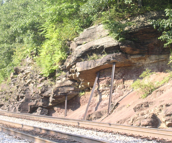
Bluefield -- Tech Road West. Go back to your car and drive or walk up to the before-mentioned crossing. The crossing is a private road leading to a few houses. You can park in shade to the west. I didn't make note of the photo ratings of the various quads, so you'll have to do your own research, but there are definitely good ops on the Tech Road side of the tracks. To the northwest of the crossing is a bizarre example of field expediency. There is a large outcropping of rock above the tracks, and some rails have been emplaced vertically to defeat the pull of gravity. There is a LOT of rock above those rails, and I'd place my bet on the Law of Gravity winning. Remember, ribbon rail on rail trains bends easily. Think how much force might be on those vertical rails. Here's a photo.
Back to the top Back to the Site Listing
Falls Mills. To leave town, backtrack to College Avenue, which is VA 102, and turn right (west, which is actually geographically north at this point). You will roughly parallel the tracks, which are on your right, but mostly out of sight. Drive to the crossroads of Falls Mills, turn right on Va. 782, and find a place to park. Listen for the defect detector at MP 368.8.
At this crossing are some interesting things. For the railroad photographer, there are nice curves in each direction, and there is plenty of off-railroad property here to get you oodles of nice photos. Martin Beran recommends that a telephoto lens might be a good item for taking pics of eastbound trains coming up the hill.
There is a very handsome older house on the corner -- brick with stone corners -- which is worthy of a photo by itself, and it can be worked into a panoramic shot. Finally, the lovely creek below can provide some entertainment between trains, as there is a myriad of birds and small animals which can be noted by the patient and sharp-eyed observer (bring some binocs, and do NOT get close to the edge of the bridge or the embankment, as it is extremely steep, and once you start going down, you'll not stop until you hit bottom -- a long way down, and a rather long, rough hike out!).
Based on our admittedly very little experience in the area, this may be the best place for action shots between Bluefield and Iaeger, a distance of some 60 miles.
Back to the top Back to the Site Listing
Falls Mills -- North. From Va. 782 off VA 102, turn left just before the tracks to follow them north. This looks to be a railroad property road, but it's actually a private (i.e., not "state maintained") road leading to a private crossing, and you are not trespassing on railroad property to drive it.
Before the crossing on this private road, park to the left, which is shady in the afternoon, and walk to the crossing. You a cross it, take pix, and get back on the south side of the tracks. This is a very nice photo area most of the day.
Do not go beyond the private crossing on the west side of the tracks, as that is railroad property.
Back to the top Back to the Site Listing
Yards.Yes, Virginia and all you other railfans out there, there really is a town named "Yards," and it really does have a railroad yard in it. Continue west on VA 102, and you'll come to the village of Yards. Most of the town's homes stretch along VA 102, but on the south edge of town, turn right onto a dirt road ("Yards Road"). [NOTE WELL: The drop off from VA 102 onto this tiny road is severe. Do not attempt it in the family sedan at a speed in excess of 1 mph. Rather, go to the mid/northern part of town, and turn east on a paved road and go down into the yard area. There is no road sign at this intersection.]
Once on Yards Road, travel north, staying on the west side of the tracks, until you are past most of this rather small coal car and MOW storage yard, and the road will improve. Counting from VA 102, there is a small yard office 0.2 miles in. Park in this area, and ask for permission to take pictures. Even though the property of the yard is not posted off limits, it is most definitely railroad property. Be polite and responsible, and chances are that you'll be able to spend at least a minimal amount of time to get a shot or two. Also, there are pretty nice homes west of you, and a grassy area which would be OK for photos between the road and the tracks, and which is not on railroad property.
To reach the east side of the tracks, from the beginning of Yards Road, go under the tracks on Waterbury Road. We didn't go over there, as it looks as if there is no non-railroad property adjacent to the east side of the tracks. Apparently, part of this yard is in Virginia, and part is in West Virginia. Besides being used for coal train storage, helper engines sometimes cut off here and return west for the next shove. Otherwise, they run through to Bluefield and turn back there.
In general, throughout this area, it is difficult to tell north from south, east from west and vice versa. The hills, the fact that the track meanders all around and about, and the fact that VA 102 wiggles all over, make such determinations difficult. Knowing when to take photos at what times is pretty much the province of someone who is quite familiar with the area. We'd suggest a little exploration before doing some serious photo sessions or train watching in the area.
Back to the top Back to the Site Listing
Nemours. Follow Yards Road to continue the trek west -- you will not be able to make a right turn onto VA 102 if you backtrack to where you left 102. As you slip back into West Virginia, VA 102 becomes WV 102. In the area of Nemours, take a right at the sign to Jimmy Louis Lake. There is a grade crossing here which gives decent views in both directions.
[Webmaster's note: The next two locations, Coopers and Bramwell are not really on the recommended tour, as they take your rather out of the way. However, both have historic and engineering/architectural value, and are recommended. If you want to take the most direct route to continue the tour, go to Maybeury, and pick up the tour there.]
Back to the top Back to the Site Listing
Coopers. Cross back into Virginia, but still on WV/VA 102, and you'll be entering the village of Pocahontas. Unfortunately, this small town is a vivid example of how tough times are up here -- it's a virtual ghost town. Take VA 120 north, back into WV, where the road will become WV 120. As you come into Coopers, there are some very interesting photographic and engineering objects. The massive bridge from the "new" Elkhorn Tunnel on the NS Pocahontas Division soars far overhead, and offers most interesting photo opportunities, but get there early and do some scouting around. You'll probably want a good telephoto for artsy-type shots. The track on the bridge under the mainline is the recently-closed Matoaka branch. This was double tracked, and was obviously a quite important coal gathering line, but the grades going northeast out of Coopers seem to be relentless.
Back to the top Back to the Site Listing
Be aware that between Coopers and Bramwell, you've got some real West Virginia mountain driving to do. Continue northeast on VA 120 towards Bramwell and U.S. 52.
Bramwell. No, trains no longer run through this town, but there are two real good reasons for visiting. First, the town itself is a jewel. This is where the money was during the coal boom of the late 19th and early 20th centuries. There were several millionaires living here, and the town reflects it. There are beautiful buildings galore, and you don't have to be a train nut to appreciate beautiful things. Second, the depot has being re-created, and there are also a large Pullman car, a rare tobacco hogshead Southern car, and 2 cabeese.
On the eastern side of Bramwell, get on U.S. 52, and travel northwest to the town of Maybeury.
Back to the top Back to the Site Listing
Maybeury. For all you machete-wielding combat railfans, here we go. From Nemours, continue on WV 102 until you begin to enter Pocahontas. Go right at the first stop sign and continue on until you see Exhibition Mine Road going off to the historic mine on the right. The roadbed and bridge abutments of the old coal branch to Boissevain are still visible, though the branch itself is long gone. [Webmaster's note: Markolf recommends that you don't take these roads if it's getting dark and/or you have motion sickness - - they twist and turn through the thick woods like good 'uns --his words, not mine!.]
Turn right and follow Exhibition Mine Road (County Road (CR) 659 if it had any signs) past the mine and up Reedsville Hollow. At Peeled Chestnut Gap, it will turn into CR-84. Continuing on a little will bring you to a three way junction, continue on the right-most road, CR-10 (again unmarked), to Maybeury. You will cross under the mainline within 2 miles; turn left onto U.S. 52.
You'll again cross under the Pocahontas Division main line under another huge bridge. Eastbound trains are fully into their climb here and slow to a crawl that makes chasing easy. Coal trains will usually get 2-3 big units on the front and another 2-3 pushing on the rear, making for an impressive sight (and sound!). You see the latest engines from GE and EMD working hard on these trains. The bridge itself is an interesting photo spot, and you can park on the gravel right before or under it.
From now on, U.S. 52 will closely follow the railroad, providing numerous good photo spots. It's not practical to describe them all, so just keep your eyes open and stop when you like what you see (and tell us about your favorites at mailto:webmaster@frograil.com).
Back to the top Back to the Site Listing
Maybeury -- Powerhouse Hill Road. Another location has been contributed by Tom Walters. When you approach Maybeury via CR-10/Barlow Road, you'll go under the tracks, and then come to a T intersection. Take a right, which will lead you to another T, this one with U.S. 52. Take a right to go away from the tracks, and then take your second left onto CR-52/14. The road will very shortly bend 90° to the right, and within this curve, take a left onto the steeply rising Powerhouse Hill Road/CR-52/12. As the name implies, the road will go up sharply and take you to the Appalachian Electric power plant, which is what you see above the tracks just west of the bridge.
This is a good road from which to view the big bridge over U.S. 52 and the mainline coming from Elkhorn Tunnel. It's good for high angle shots, and is definitely a cold weather location, as leaves will pretty much ruin your photo ops. Regardless of the season, you'll want to pick the location that works best for you, so you might consider parking near the mobile homes, and then walking the road. Be aware that like most rural West Virginia roads, what looks like a very minor road carries a lot of traffic, much of which seems to move amazingly fast. Be careful.
Back to the top Back to the Site Listing
Switchback. It's name evoking images of an ancient method of conquering the mountain, today's Switchback provides a good photo spot. Not much more than a mile from Maybeury, turn right onto the small gravel road leading down the embankment which will take you to the tracks. Either park before crossing Elkhorn Creek, or, if you are the adventurous type and so equipped, follow the ford through the creek and up to the tracks. Good light and sight lines at this location.
Back to the top Back to the Site Listing
Elkhorn. This is the "next wide spot in the road."Turn right onto Elkhorn Station Road (CR 52-11) and go to the grade crossing. There is a small gravel spot just before the crossing where you can park nicely out of the way. A talking defect detector is just east of here, at milepost 381.0. Be aware, though, that westbounds and especially returning helpers make good speed here, so the detector will not help you at this location. Again, good sight lines for AM and PM shooting.
Back to the top Back to the Site Listing
Kyle. Continue on U.S. 52 through the village/crossroads of Powhatan. There is little more here than a grand name and a mundane passing siding which is below the level of U.S. 52. As you come in to Kyle, there's a wide gravel spot in front of the church directly at the city limits.
Another good spot is about 100 yards down the road. Make a hard right turn onto Kyle Road and you'll again end up at a grade crossing with some space to park. This is the west end of the passing siding.
Northfork. As you reach the city limits of Northfork, there's a spot suitable for pulling over on your right side. Otherwise, this is another dying coal town.
Keystone. Only a stone's throw from Northfork via U.S. 52, this town hosts the first active coal tipples, counting from Bluefield. The biggest one is located to your right as you enter town. From Main Street, turn right onto Bridge Street and park on the left before crossing the tracks. From this spot, you can shoot into the facility. Some really nice old buildings are still standing, including the company post office, but the large fence to catch the coal dust makes photos difficult other than from here.
Continuing left alongside the tracks you will reach a rather impressive yard that serves the large tipple plus a smaller truck-dump loader alongside the yard. While not posted, do make sure you stay out of everybody's way here. [NOTE WELL: Let me reinforce Markolf's warning here. Those huge coal trucks, like trains, are hard to stop. Also, those guys are paid based on production, not time, so they're naturally in a hurry. Add in a few whizzing log trucks on the main road, and you've got a whole lot of dangerous things happening in a compact space. Be very, very careful in such areas .]
There's a better spot to watch the activity at this loader. Go back onto Main Street (U.S. 52) and continue west for half a mile. There's a gravel spot on the right shoulder of the road just next to and above the loader. This must have been arranged by a railfan!
Both Northfork and Keystone are your archetypical West Virginia coal towns. Old brick buildings snuggled up closely to the tracks and creek, coal dust everywhere, and not a shopping plaza in sight.
Back to the top Back to the Site Listing
Eckman. Continuing past the pull-off above the loader, you reach a bridge crossing over the railroad. Turn right before the bridge, and follow the road under it. It parallels a short coal branch up Dans Branch Hollow and within half a mile reaches another active coal tipple. There's a convenient pull-off here that's off the mine property and perfect for watching the action. The spur ends a short distance past the loader.
Continuing past the loader up the hollow takes you to what must have been one of the poorest areas in the whole state. Those depressing homes and properties have been bulldozed out of existence, and all that's left is the hollow, the road, and the tracks. As of December 2007, Tom Walters reports that the tipple is still active, and that there was a string of MT's awaiting loading.
Back to the top Back to the Site Listing
Landgraff. Here'sanother rather obscure site, and certainly one which will challenge photographers. You'll see references to "Landgraaf" and "Landgraff", but the latter will probably be on the maps. Probably the original was the German "Landgraaf", and it has been modified to the more Anglo "Landgraff" over the years. No mind, as the site has curves, mountains, and the Elkhorn Creek to keep things interesting. During the flood of 2001, much of what had been Landgraaf was destroyed. There are still plenty of photo ops at the grade crossing and along the curves in the area, but the toll on human living in the valley was pretty awful. Take your pix, but leave very tiny footprints, and maybe you might want to help the folks in the area.
With a tip of the hat to Bob Eisthen for the heads up for this site.
Martin Beran reports, since 2002 Landgraaf is the location of the Elkhorn Inn, established in the old club house and the only building remaining after the flood. Dan and Elisse Clark run this bed and breakfast and it can be considered to be one of the "rail fan heavens" these times. Several rooms face the busy track and Chef Dan cooks a fine meal once you come back from a long day out on along the rails. A balcony with an awesome view and the monitor showing block occupancy around the Inn are the icing on the cake. The perfect location for staying while exploring the Pocahontas Line.
Back to the top Back to the Site Listing
Vivian. Here's a location on the tour that was added well after the tour was first constructed by Markolf and Tony. This is so obscure that you can drive by it several times and never suspect that it's there, and that's a shame, as it's a really interesting railfan site. Just past Keystone on U.S. 52, you'll see a small place name sign announcing Vivian. Continue on up the hill, and you'll see East Vivian Road going off on your left. This is the road you want, but the turn is too sharp, so continue down the hill on U.S. 52, and make any convenient U-turn. Go back up the hill, and take East Vivian Road and go down the narrow, steep road to Vivian Bottoms. Cross the tracks and park near the ball field. This entire area used to be a large operation of the Peerless Coal and Coke Company. The "company store" ruins still stand.
There is a series of interesting curves here, and most are photographically accessible from the (compass) south side of the tracks. The lighting is complicated because of the hills, curves, trees, and the relatively open areas. You're advised to spend some time here as a student before you start wasting a bunch of film or bandwidth.
I'd like to thank Mike Ritschdorff for the heads up to this site.
Back to the top Back to the Site Listing
Kimball -- East Portal. U.S. 52 runs north of the tracks now, making for difficult photography. After passing through Vivian, Landgraff, and Bottom Creek, the next significant place is Kimball, once the site of an impressive yard. Virtually nothing is left of it, and what little is left is rusting and overgrown. There is an ox-bow in Elkhorn Creek, whereby the creek goes straight north, and then whips around to go straight south, and then continues on to the west and Welch. U.S. 52 goes through town on the north shore of the Creek, while the main line disappears into a tunnel under the hill that is the reason for the ox-bow, and reappears on the west side of town. Kimball hosts the McDowell County Coal Heritage Museum, but it too seems to be closed.
As for the east portal of the tunnel, Shane Miller reports that you can park on the shoulder of U.S. 52, and get some good shots from public property.
Back to the top Back to the Site Listing
Kimball -- Big Four. As you continue west on U.S. 52, in the area of Big Four, there used to be a K-Mart on your left by the tracks. The building was vacant, but has now been replaced by a scaled down Wal-Mart Supercenter. The area affords limited train viewing. Turn left onto CR 52-37 (Plaza Drive) to get there. This is more than just a place to see a train, it's actually the site of a crossover, CP-Big Four, and the signals in the area are still fairly new, thanks to the very serious flooding during 2001. The entire Control Point was washed out. For a time, the signals were temporarily affixed to poles after the floods.
More thanks are due to Joe Shaw, Shane Miller, Marcus Neubacher and Richard Nelson for clarification and additional info concerning this location.
Back to the top Back to the Site Listing
Superior. Beyond Kimball, still on U.S. 52, you'll soon reach the site of the Huger tunnels. Before you get to Superior, look for a flashing yellow traffic light at the Baptist Church sign. Park off to the side of the road, cross the ditch (watch out for the brambles) and walk through the weeds. You'll soon be on top of the tunnel with a great eastbound shot. Richard Nelson, who was kind enough to contribute this location to Frograil, says the best photo times are from near noon to mid-afternoon.
Back to the top Back to the Site Listing
Maitland. Located between Superior and Maitland, but technically in Maitland proper, is the huge Cannellton Coal Preparation plant, located directly on the main line. While definitely and obviously posted off-limits, it can be viewed from U.S. 52 without trespassing.
Martin Beran reports that if you travel a little further on U.S. 52, before the road makes a left bend into the outskirts of Welch at the end of the long straight run, turn right on Maitland Rd (CR 52/17) and follow the road to the grade crossing of Airport Rd (CR 52/05). The spot gives you a good view into the long curve towards Welch.
Welch -- Save a Lot Area. Welch is the county seat of McDowell County, and is the largest town between Bluefield and Williamson. It is most definitely a coal train town. There are several places to see and photograph trains in the area, and we'll give you two. As you enter town via U.S. 52 from the east, there will be a large Save a Lot store, with a large parking lot on the north side of the highway. The mainline of the NS Pocahontas Division is behind the store and parking lot. Go into the parking lot and drive towards the tracks, turn left, and drive along the tracks, past the supermarket, and back to the cool, shady trees well back from the tracks. Here, you can get your lawn chairs out, open up the cooler, and watch 1-3 trains per hour parade by. There is pretty good photo access here most of the day, and this is, all-in-all, a pretty good place to relax and watch NS strut its stuff.
Back to the top Back to the Site Listing
Welch -- Downtown. U.S. 52 and WV 16 meet downtown. Take WV 16 north to just after going under the mainline. There is a small street on your right leading up to the tracks. From the west, trains go through a valley with much sound and fury -- you can't see them, but you sure can hear them. The trains explode into view, and cross the Tug Fork and WV 16 via a rather low, curving bridge. You can get nice AM shots of trains coming over the bridge, but artsy shots of trains coming out of the tunnel to the east are probably impossible here without trespassing onto railroad property. This is, besides illegal, quite dangerous -- actually, it's downright stupid. Scout around in this area, and you'll probably come up with some really nice photo ops of trains going over the bridge/river.
A nice overview of the city can be head by following U.S. 52 west, heading up the mountain. After about a mile, you arrive at a scenic overlook on your right.
Back to the top Back to the Site Listing
Gary -- Tug Fork Branch. South of Welch, several coal branches head "up the holler" which give a good impression of how coal resources were tapped. If you'd like to explore the Tug Fork branch, follow U.S. 52 west of town as above and turn left (south) onto WV 103 at the large intersection. You should be aware that this side trip is not a quickie out and back. Plan on spending several hours on the branch. If you're lucky enough to catch a train working one of the tipples, you'll not want to leave in a hurry. Like every other part of this tour, it really is difficult to hurry here, and doing so will not only be dangerous on these roads, but will also severely reduce your enjoyment of this adventure into pure railroad heaven.
Today's Tug Fork branch has three active tipples. WV 103 twists and turns up the valley, passing by numerous spots formerly occupied by coal loaders long since torn down. A rather impressive site is located down and off to your right shortly before reaching Gary. Remnants of the old coke ovens and a concrete silo are still visible, plus a spindly conveyor delivering coal from high up the mountain. A rather sizeable yard is located here and is still partly in use.
Back to the top Back to the Site Listing
Elbert -- Tug Fork Branch. Upon reaching the post office in town (Gary), turn right off of WV 103 and onto CR-13. Climbing out of town and continuing south, you shortly reach Elbert, site of two active loaders. The first one is off to your right, following the curve in the road and over the grade crossing into Filbert [NOTE: Elbert and Filbert are easily confused, but are different places]. Photography here is difficult at best. You might try and ask for a visitor's permit, but Tony didn't try it since the loader was closed over the weekend.
Backtracking from here to the grade crossing, then turning right onto the dead-end road parallel to the track will take you to the Black Wolfe tipple, a pocket-sized loadout serving a somewhat larger mine complex on the hillside above. Viewing and photograph are very good here. Watching an engine and cars navigating the crooked rails deeply sunken in coal dirt is interesting to say the least!
Black Wolf -- Tug Fork Branch. Having visited the raison d'etre for this part of the Tug Fork branch, go back to Gary and turn right (south) onto WV 103 in front of the post office. This will take you to the tiny community of Black Wolf where there is, of all things, a rather nice golf course! Turn right (south) onto WV 161 here. The old Anawalt branch along WV 161 north of here is abandoned, but WV 161 heading south will take you up the South Fork to the end of the hollow at Monson. There's another active loader here, which is also very conveniently viewed and photographed from a scenic overlook just before reaching the mine property entrance. Don't be fooled by the DeLorme map, this line is not abandoned!
This concludes our tour of the Tug Fork branch, so follow WV 161 back to WV 103, and then WV 103 back to Welch and U.S. 52. It's easy to get lost in this maze of hollows so check your map often and don't forget to take it easy -- you could be staring at a close-up view of a huge coal truck's radiator at any of the hundreds of bends in the road!
Back to the top Back to the Site Listing
We now resume our tour of the Pocahontas route. Again, there's a choice to be made. You can either continue west on U.S. 52 to Roderfield and rejoin the main line there for the trek west, or you can closely follow the track on CR-7 and rejoin U.S. 52 at Roderfield. The first option will take you only about 15 minutes, while CR-7 will easily swallow you for 45 minutes or more. That said, be warned: If you're chasing a train, stay on U.S. 52 - you'll never make it on CR-7.
Now, Markolf and Tony are true railfans, and want to follow the tracks, so grab your machete, and go north back into Welch on WV 16 (left at the big intersection returning from the Tug Fork Branch) and follow WV 16 all the way through town, going under the bridge downtown which was discussed above. Eventually, you will come to a three-way stop sign in front of the hospital. CR-7 is the unmarked road to your left (who stole all the signs anyway?) Follow it out of town.
If you want to get quickly further along to Roderfield, however, you can continue west from Welch via U.S. 52, and then take a right on CR-7 to go into Roderfield. Tony has had reports that some fans don't like CR-7 between Welch and Roderfield, and that it's not worth the difficult drive, but Markolf and Tony prefer the route that most closely follows the railroad. You be the judge, based on the time available, the quality of your maps and research, and the ability of your vehicle to handle some rough mountain territory.
Back to the top Back to the Site Listing
Capels (Farm). After passing Hemphill, you will reach Capels. The tracks come back into view on your left after passing through a tunnel. Turn left onto the gravel road here and go down to the tracks. Head up the incline before the bridge to reach track level. To your left is a tunnel and a bridge over the Tug Fork. To your right is a concrete coaling tower which marks this location as the storied helper base of Farm. The tower would be so hard to knock down that N&W simply left it standing. Similar structures built to standard plans still stand at Bluefield and Iaeger.
The gravel road continues along the track and provides access to the tower and the signals just east of it. There are three tracks here, widening to five just west of the tower. The road you're on is not posted and good pictures can be had here. In steam days, both the road and helper engines replenished their coal and water supplies here, and tonnage was set off by heavy trains to compensate for Elkhorn Grade, which starts just east of Welch, a few miles ahead.
To get back onto CR-7, you should turn back the way you came. You can, however, continue to follow the gravel road, which will eventually get back to CR-7 as well, but the ascent requires at least a good off road-capable truck, preferably a 4x4. You have been warned! CR-7 follows the main line west of here, but runs high above track level. Nice overhead views looking down onto the tracks can be had from multiple locations. However, this area is not one for casual photography. You'll have to do some on-the-ground research, and winter (no leaves on the trees) would be best. It can be very, very cold up there in the winter, so you're going to have to pay serious attention to life support precautions before you even leave your house. This is a place NOT to fan by yourself.
Back to the top Back to the Site Listing
Davy. The road meets the tracks again at Davy, crossing over to the south side at grade. Keep hard right immediately after the crossing! Continue parallel to the tracks and hang a left turn at the stop sign. This looks like a good photo location.
Marytown -- Twin Branch Tunnels. Between Davy and Marytown, the Twin Branch scrunches up and back down in an ox-tail loop. Rather than go the long way, the railroad has punched two tunnels through the inside of the loop. These are called the Twin Branch Tunnels, and there is a small parking area between the two of them. This is a morning location, as there is a mountain to the west, goofing up light virtually all afternoon. Even though this parking area is off CR-7, you've got to know it's there to be able to find it. Do your map work ahead of time, because you'll not be able to get to this location without prior knowledge that it's there.
With a tip of the hat to Bob Eisthen for the heads up for this site.
Back to the top Back to the Site Listing
Marytown. Leaving Davy, the railroad and road both go through separate tunnels piercing through Indian Ridge. They meet again at the collection of houses known as Marytown. Two good spots here: one is just to your left after crossing over the blue truss bridge onto what seems to be an abandoned coal loadout site. The other one is about 0.3 miles ahead, also on your left. Here, a gravel road leads down to the tracks. Keep right and you will come to a large, open area next to a bridge. Just west of here begins a little-used passing siding.
Roderfield -- Big Sandy. There's a talking defect detector at Big Sandy [MP 413.0], alerting you if you carry a scanner. West of Big Sandy, the main line passes through two tunnels within one mile of track. Between these tunnels, two gravel roads lead up the embankment to your left affording access to good photo spots. The second access road is clearly marked off limits, but at the time of my visit the first wasn't. Either way it's best to park down and walk up, unless you want to again test your 4x4 skills.
Back to the top Back to the Site Listing
Roderfield. This is the junction between U.S. 52 and CR-7, and also between the main line and what used to be the Spice Creek Branch. The trackage is still in place from here east along U.S. 52 to Erin, but hasn't seen a train in at least 5 years. One loader is still standing as well, while several others have been dismantled along with their associated trackage. Roderfield itself is hardly more than a gas station, but there is a pretty impressive sawmill just west of town. This facility has rail service.
Just west of Roderfield, you'll encounter the remnants of Clear Fork Junction. The place is still there, but the junction isn't. All that remains is the old bridge across the river. The roadbed of the branch up Clear Fork is still clearly visible, but is, alas, unused.
From here on, the railroad crosses the Tug Fork twice, then stays on the far side of the river. There are few good views from U.S. 52.
Sandy Huff. Continue westbound on U.S. 52, and you'll see appropriately named Sandy Huff Branch Rd. (CR 52-21) on your right side. This will take you trackside. There's a good-sized gravel lot on the left with ample space for parking and good visibility for photos.
Iaeger. The second largest town between Bluefield and Williamson (after Welch), this place is big on railroad action. Incidentally, "Iaeger" rhymes with Chuck Yeager's last name. Chuck, as every school boy should know, is from West Virginia.
Following the signs for downtown, and turning left before the big bridge, will take you to a useful spot directly under the bridge. Good views of both east- and westbounds can be had here, and the two bridges over the Tug Fork are also visible. Following the road into town brings you to more good spots.
Iaeger is the site of Auville Yard, a sizeable facility serving the Dry Fork branch that runs all the way south to Cedar Bluff and Carbo, Virginia, on Norfolk Southern's ex-N&W secondary main between Bluefield and St. Paul. A maze of smaller coal branches split off at various points south of here. The branch sees up to 8 trains a day, which is pretty impressive for a branch.
Auville Yard is reached by following the signs for WV 80, then, where WV 80 takes a 90° turn over the yard throat, continuing straight into the road marked "dead end". On the right are the yard office and old coaling tower. Martin Beran reports the coal tower is still in good shape and you can get nice shots of older branch line diesels parked under or close to it. You can park along this road in a few places. Get as far to the east side of the road (farthest away from the tracks) as you can for two good reasons. There are nice trees which will keep you reasonably cool through most of the morning. Also, there are lots of coal trucks through here, going up to a mine at the end of the road -- we've mentioned before how much room they tend to take up. Whatever you do, make sure you don't block the entrance to the coal mine up the hill on the left unless you want your car flattened by 30 tons of West Virginia bituminous!
This level, gravel road next to the yard is a good photo spot for northbounds coming off the branch and the yard switcher that is usually working the north end of the yard. Actually, where WV 80 crosses the yard's throat, the tracks coming and going in and out of the yard are the east/south and west/south legs of a wye. The mainline is the third leg, i.e., the east/west leg. Therefore, you'll get great photos of all arrivals and departures at the north end of Auville, as well as drilling by the yard job, but you'll not be able to see any main line action.
WV 80 parallels the yard on the west side across the river, but visibility is poor. There are two old, abandoned loaders on the south end of the yard still standing, and a rickety old wooden trestle used to cross the river is there as well. You should definitely keep off this thing! Because WV 80 carries heavy traffic at the yard throat, photos are not recommended from that location. Vehicular entrance to the yard is on the west side of the yard, south of WV 80 just after crossing the tracks. It is clearly and abundantly posted. Therefore, Auville yard is pretty much an AM photo site.
Back to the top Back to the Site Listing
Litwar. Going back to U.S. 52 and continuing west for about a mile, you reach a gas station/convenience store. Turn left here and you are on CR-1 which follows the tracks up to the tiny hamlet of Mohawk. After less than a mile, the road reaches the humongous coal tipple at Litwar. This monster operates 7 days a week, and is switched by main line trains setting out blocks of empties and picking up strings of loaded cars. There's good visibility of trains switching from the other side of the tracks off CR-1, or you can turn off to the right before CR-1 crosses the tracks. You won't be able to reach the plant itself, though.
With a tip of the hat to Bob Eisthen for the correction to this site.
Back to the top Back to the Site Listing
Panther. Continue west on CR-1 for about 8 miles beyond Litwar. Even though you're close to the railroad, the creek, hillsides and trees are constantly in your way. However, when you get to the crossroads of Panther, you'll be treated to a rare site: Panther is a grade crossing shot down a long straightaway! This is rare in this part of West Virginia! To continue west, cross the tracks and take a left, as CR-1 takes you ever deeper into the West Virginia wilderness.
Bob Eisthen has given us this data, allowing a short extension of the Pocahontas Division tour.
Back to the top Back to the Site Listing
Mohawk. Perhaps 3 miles further west from Panther via CR-1 is Mohawk, although even this is subject to argument, because the deLorme shows it as "Mohawk", MapQuest shows it as "Wyoming City" (although it's a little further northwest, and Steam Powered Video shows both "Mohawk" and "Wyoming". Tony thinks SPV is correct, as it shows the two places no more than a mile apart. deLorme shows a county road to the south of the Tug Fork, and it is apparently accessed from "Bull City Road" in what must be Wyoming. This is a puzzling, complicated, and most enjoyable area to try and figure out. What is more important is the fact that this is the end of our ability to follow the tracks west from Bluefield. From here northwest, the railroad enters the wilderness, and without a helicopter, we can't follow it. This is a fitting place to temporarily end this tour.
Bob Eisthen has given us this data, allowing a short extension of the Pocahontas Division tour.
Back to the top Back to the Site Listing
For now, this is the end of our tour. So, how'd you like to make it an even better tour by extending it further west and north? We'd love to have a contributor take up where Markolf, Bob, and Tony have left off. Heck, we want to see it go all the way to Lake Erie. Clearly, we need your help.